STORM REPORT
Tropical Storm Nora - September 1997
Prepared by the
Flood Control District of Maricopa County
2801 W. Durango Street
Phoenix, Arizona 85009
(602) 506-1501
by:
Stephen D. Waters
Senior Hydrologist / ALERT Program Coordinator
Engineering Division, Special Projects Branch
![]()
Table of Contents
Introduction 1
Appendix A: NWS Advisories, Watches, and Warnings 18
![]()
INTRODUCTION
The purpose of this report is to present in a concise manner selected rainfall, runoff, and statistical data from the storm event (Tropical Storm Nora) of September 25th and 26th, 1997, which was most intense in the northwest portion of the County. The majority of the data presented was collected by the Flood Control District's (FCD) ALERT system, with contributions from the Phoenix National Weather Service (NWS) Forecast Office.
The goal of this report is to present and record data for general information purposes, and as a guide for future prediction of water levels and discharge rates for FCD structures, particularly the Wickenburg Dams and Washes, the Hassayampa River, and Centennial, Tiger and Jackrabbit Washes.
The synoptic history of Hurricane Nora is paraphrased from a preliminary report by Edward N. Rappaport of the National Hurricane Center…
Hurricane Nora formed early on the 16th of September about 250 nautical miles to the southwest of Acapulco. It originated in a large area of disturbed weather that had slowly become better organized while drifting west-northwestward during the previous few days. Analysis of satellite pictures indicates that this activity was likely related to a westward-moving tropical wave that crossed from Africa into the Atlantic hurricane basin on the 30th and 31st of August. The northern part of the wave was associated with the formation of Hurricane Erika in the central tropical Atlantic, while the southern part continued westward through the Caribbean Sea and northern South America, and arrived in the eastern Pacific basin on September 12th.
Nora matured in an environment of relatively light wind shear, and much of its development appears to have been related to variations in sea-surface temperature (SST). Nora formed over very warm water (29-30° C). Deep convection quickly increased and became organized in well-defined bands on the 16th, and further strengthening occurred over the next two days. The first signs of what would become a rather large and ragged eye were detected in infrared satellite pictures early on the 18th. By late that day, Nora was a hurricane with 90-knot sustained winds.
During Nora's first few days, the winds around a mid-level high over northern Mexico helped direct the tropical cyclone slowly toward the west-northwest. From midday on the 18th to early on the 20th, however, Nora nearly stalled and weakened significantly. The height, amount and organization of convection decreased and the eye disappeared. The maximum wind is estimated to have decreased to 65-knots. This weakening is presumed to have occurred in response to the hurricane's prolonged stay over waters cooled by upwelling beneath its circulation. Analyses in this part on Nora's wake show SSTs cooled by about 2° C, on average, to about 27° C.
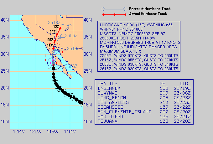
By late on the 20th, Nora was on the move again, at 5 to 10 knots toward the west-northwest, roughly parallel to the southwest coast of Mexico. Nora then rapidly restrengthened and the eye reappeared, initially with a diameter of 15 nautical miles. Nora reached its peak maximum wind speed of 115-knots near 1200 UTC (Zulu) on the 21st.
On the 21st through 23rd, Nora's track converged with and then followed the track previously taken by Hurricane Linda. In that area, Linda had been the strongest eastern Pacific hurricane on record jest a few weeks earlier and its circulation had induced lower SSTs. Nora gradually weakened over Linda's wake, with the eye temporarily broadening to a diameter of about 50 nautical miles and the eyewall becoming broken. Estimated wind speeds decreased to about 70-knots at 1800 UTC on the 23rd.
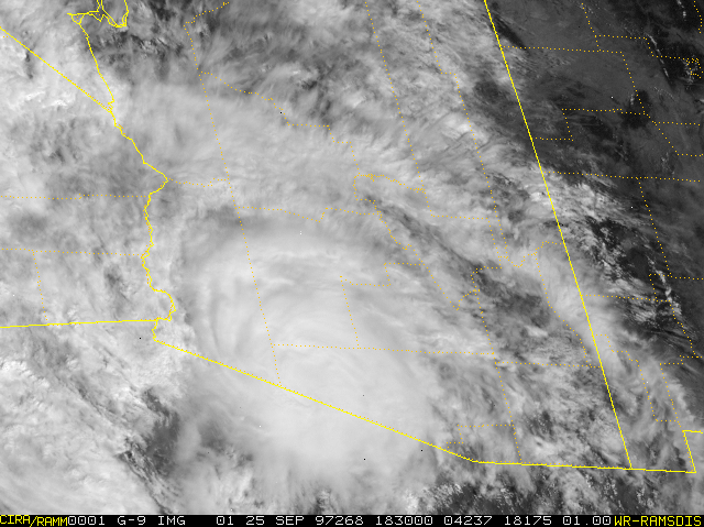
An omega-like blocking pattern developed over the western United States during the last week of September. This left a weakness in the height pattern to the north of Nora and eventually a trough with a cut-off low to the northwest of the hurricane. The track of Nora became north-northwestward and then northward on the 24th. This carried Nora over yet another SST anomaly, a large area of water more than 2° C above normal abutting the west coast of Baja California. Nora remained over waters of at least 26° C all the way to its landfall on the morning of the 25th at Punta Euguenia and then about 50 nautical miles south-southeast of San Fernando, Baja California. Hence, Nora had restrengthened slightly, and then weakened less quickly than most tropical cyclones in that area. It was still at hurricane strength during its landfalls (on Mexico and the US).
Nora was accelerating northward at landfall, steered by the flow associated with the trough to its northwest. The center of the cyclone crossed the Baja California peninsula at 20-25 knots and traveled up the western shoreline of the Gulf of California. It crossed in the United States near the CA/AZ border, still a tropical storm, at approximately 2100 UTC (2:00 PM MST) on the 25th. Most of the heavy precipitation was then located to the northeast of the storm center.
Rapid weakening ensued and winds dropped to tropical depression strength near 0000 UTC (5:00 PM MST on the 25th) on the 26th, when the center was located about midway between Blythe and Needles, California. The low-level center was moving toward the north-northeast as it degenerated early on the 26th (which was late on the 25th in MST). A remnant circulation aloft persisted and is likely to have been responsible for a period of near hurricane-force winds observed at the NWS Cedar City Doppler radar, located in the mountains of southwestern Utah at an elevation of about 10,600 feet.
The residual area of cloudiness and showers gradually became more diffuse over the following two days while moving generally northeastward, through portions of Utah, Colorado, Idaho and Wyoming.
RAINFALL
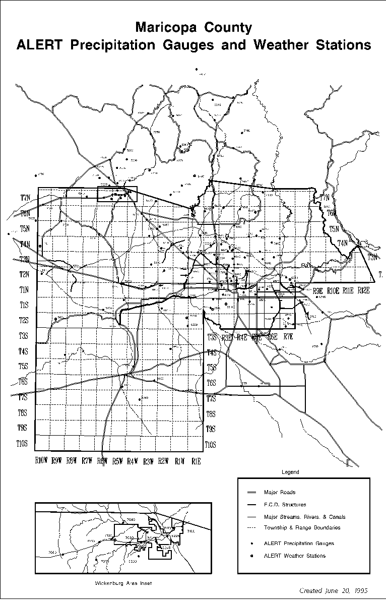
Rainfall amounts were highest in the northwestern portion of Maricopa County, in eastern La Paz County and in the western and southern Bradshaw Mountains in Yavapai County (Figure 2).
The calculated 24-hour, 100-year rainfall amount in NW Maricopa County is approximately 4.20 inches. This amount was exceeded at six ALERT measuring sites (Table 1).
Three ALERT gages recorded more than five (5) inches of rain, eight gages recorded more than four (4) inches, twenty-six gages recorded more than three (3) inches, thirty-nine gages recorded more than two (2) inches and fifty-one gages recorded more that one (1) inch of rain.
Figure 1 shows selected hyetal bar-graphs for four ALERT stations in northwest Maricopa County.
Figures 3-10 show spatially the distribution of storm total rainfall recorded at ALERT rainfall stations in the affected Meteorological Services Project zones.
Table 2 presents storm-total rainfall amounts measured at regional airports and by National Weather Service cooperative observers.
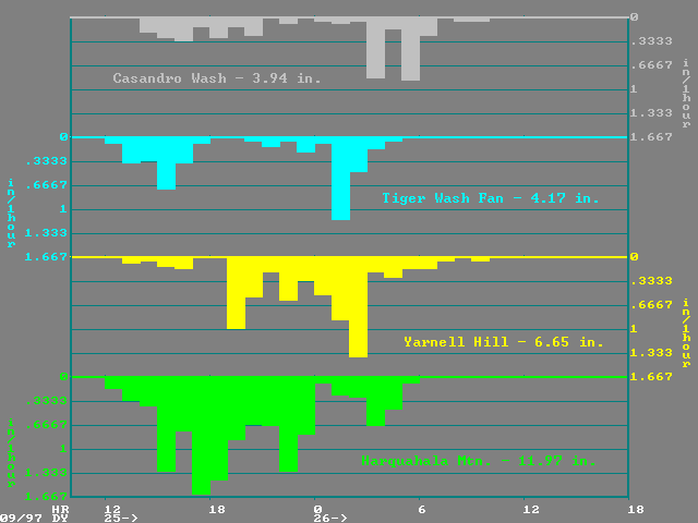
FIGURE 1
|
Tropical Storm Nora Rainfall Totals |
||||
|
Amounts > 1.00 Inch for 9/25/97 10:00 through 9/26/97 18:00 |
||||
|
SENSOR_NAME |
SENSOR_ID_# |
ELEVATION |
AMOUNT |
LOCATION |
|
Harquahala Mtn. |
5185 |
5681 |
11.97 * |
Top of Harquahala Mtn., 36 mi. WSW of Wickenberg |
|
Yarnell Hill |
5290 |
5128 |
6.65 |
1 mi. ENE of Yarnell, Yavapai County |
|
Wilhoit |
5365 |
5043 |
5.39 |
At Wilhoit, 10 mi. SSW of Prescott, Yavapai County |
|
Mt. Union |
5380 |
7495 |
4.57 |
Top of Mt. Union, 10 mi. SSE of Prescott |
|
Centennial Wash |
5180 |
2417 |
4.53 |
1 mi. N of US 60, 19 mi. W of Wickenburg |
|
Horsethief Basin |
5700 |
6702 |
4.37 |
At HB Recreation Area, 6 mi. SE of Crown King |
|
Tiger Wash Fan |
5140 |
1605 |
4.17 |
1 mi. W of Eagle Eye Rd. and 4 mi. N of Salome Highway |
|
Gladden |
5170 |
2198 |
4.06 |
US 60 at Gladden, 34 miles W of Wickenburg |
|
Hassy R. @ Box Canyon |
5305 |
2245 |
3.98 |
6 mi. N of Wickenburg on Hassayampa River, Yavapai Co. |
|
Casandro Wash |
7090 |
2240 |
3.94 |
On US 60 bridge, 2 mi. West of US 60 / US 93 |
|
Crown King |
5715 |
6783 |
3.90 |
Crown King, Bradshaw Mtns, 24 mi. SSE of Prescott |
|
Flores West |
7025 |
2625 |
3.90 |
Along US 93, 3.2 mi. NW of the US 93 / US 89 junction |
|
Upper Tiger Wash |
5130 |
2198 |
3.82 |
11 mi. S. of Aguila off Eagle Eye Road |
|
O'Brien |
5320 |
2798 |
3.70 |
11 mi. NE of Wickenburg, Yavapai County |
|
Casandro Dam |
7130 |
2180 |
3.70 |
1.1 miles W of the US60 / US93 intersection |
|
Hartman Wash |
7060 |
2488 |
3.66 |
On US 60 bridge, 6.3 mi. West of US 60 / US 93 |
|
Towers Mtn. |
5340 |
7528 |
3.62 |
3 mi. NW of Crown King, Yavapai County |
|
Martinez Creek |
7010 |
2300 |
3.43 |
1 mi. East of the US 93 / US 89 junction |
|
Sols Tank |
7030 |
2690 |
3.43 |
6.3 mi. WNW of the US 93 / US 89 junction |
|
Mid-Martinez Creek |
7005 |
2725 |
3.39 |
4.4 mi SSE of the US 89 / SR 71 junction |
|
Flying E Tank |
7070 |
2480 |
3.31 |
6.3 mi. WSW of the US 93 / US 89 junction at Wickenburg |
|
Sunset FRS |
5230 |
2100 |
3.15 |
3/4 mi. WSW of the US 60 / US 93 intersection in Wickenburg |
|
Stanton |
7000 |
3250 |
3.15 |
6.5 mi. East of Congress, Yavapai County |
|
Vulture Mine |
5260 |
2311 |
3.11 |
3 mi. SW of Wickenburg |
|
Hassy R. @ Wagoner Rd. |
5350 |
3785 |
3.03 |
6 mi. ESE of Kirkland Junction |
|
Black Mountain |
7050 |
2617 |
3.03 |
Along US 60, 9 mi. West of US 60 / US 93 |
|
Flying E Wash |
7080 |
2302 |
2.99 |
On US 60 bridge, 3 mi. West of US 60 / US 93 |
|
Minnehaha |
5335 |
5602 |
2.95 |
8 mi. E of Wagoner, Yavapai County |
|
Sols Wash nr Matthie |
7040 |
2220 |
2.95 |
Sols Wash at SPRR bridge, 2 mi. N. of Wickenburg Airport |
|
Hassy R. @ US 60 |
5225 |
2035 |
2.87 |
Hassayampa River at US 60/93 in Wickenburg |
|
Black Hill |
7035 |
2560 |
2.83 |
2.3 miles WSW of the US 93 / US 89 junction |
|
Smith Peak |
5190 |
5131 |
2.80 |
Harcuvar Mtns., 13 mi. NW of Aguila |
|
Wickenburg Airport |
7120 |
2383 |
2.80 |
4.5 mi. West of the US 60 / US 93 junction |
|
Sunnycove FRS |
5245 |
2200 |
2.76 |
1 mi. SW of the US 60 / US 93 intersection in Wickenburg |
|
Congress |
7020 |
3000 |
2.64 |
Junction of US 89 and SR 71 |
|
Powder House Wash |
7110 |
2120 |
2.64 |
1/2 mi. NE of US 60 and Constellation Rd., Wickenburg |
|
Gila Bend Mountains |
5050 |
1620 |
2.44 |
16 mi NW of Painted Rock Dam off Agua Caliente Rd. |
|
Constellation Road |
7100 |
2220 |
2.36 |
1.4 mi. NE of the US 60 / US 93 junction |
|
Sunset Point |
5730 |
3378 |
2.09 |
Sunset Point Rest Area on I-17, 10 mi. N of Black Canyon City |
|
Arizona Hunt Club |
5775 |
3805 |
1.97 |
5 mi. NNW of Cordes Junction |
|
Columbia Hill |
5685 |
2393 |
1.85 |
5 mi. NNW of Castle Hot Springs |
|
Centennial Levee |
5120 |
1298 |
1.81 |
2 mi S. of I-10, 1 mi. E. of W. County border, Harquahala Valley |
|
Jackrabbit Wash |
5215 |
1798 |
1.77 |
16 mi. NNE of Tonopah, 20 mi. SSW of Wickenburg |
|
Prescott Valley |
5820 |
5228 |
1.77 |
5 mi. N of the intersection of SR 69 and Roberts Rd. |
|
Dewey |
5805 |
4775 |
1.73 |
5 mi. E of Dewey off Orme Ranch Rd. |
|
Sols Wash |
5275 |
2771 |
1.54 |
Intersection of SR 71 and US 93, 16 mi. NW of Wickenburg |
|
Saddleback FRS |
5110 |
1177 |
1.46 |
7 mi. WSW of Tonopah in Harquahala Valley |
|
Narrows Dam |
5150 |
1960 |
1.34 |
5 mi. SE of Salome off Salome Highway |
|
Mt. Oatman |
5000 |
1720 |
1.26 |
8 mi. WSW of Painted Rock Dam |
|
I-17 @ 169 |
5790 |
4750 |
1.18 |
I-17 at SR 169 (Cherry Rd.) |
|
Harquahala FRS |
5125 |
1420 |
1.02 |
10 mi. WNW of Tonopah in Harquahala Valley |
|
* New State record for a 24-hour period |
||||
|
TABLE 1 |
||||
 FIGURE 2
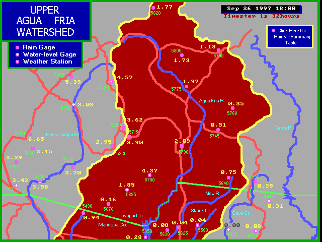
Figure 3: Upper Agua Fria Watershed
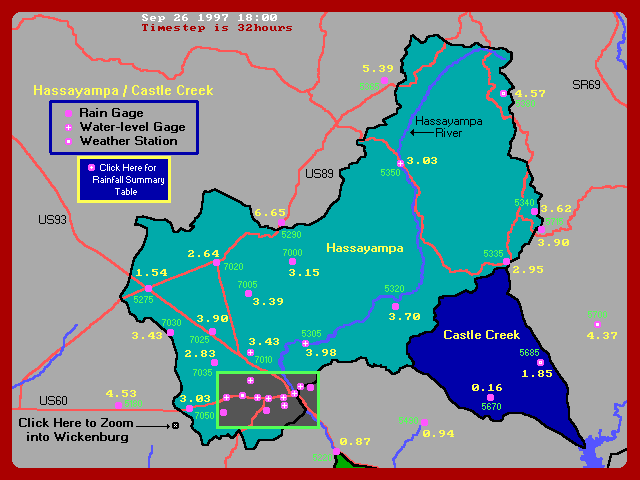
Figure 4: Upper Hassayampa and Castle Creek Watersheds
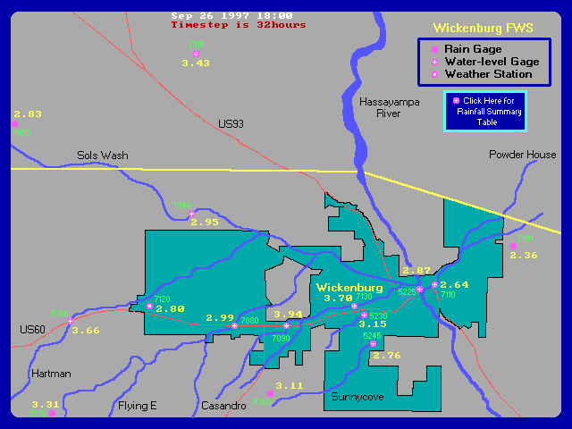
Figure 5: Town of Wickenburg and Surrounding Area
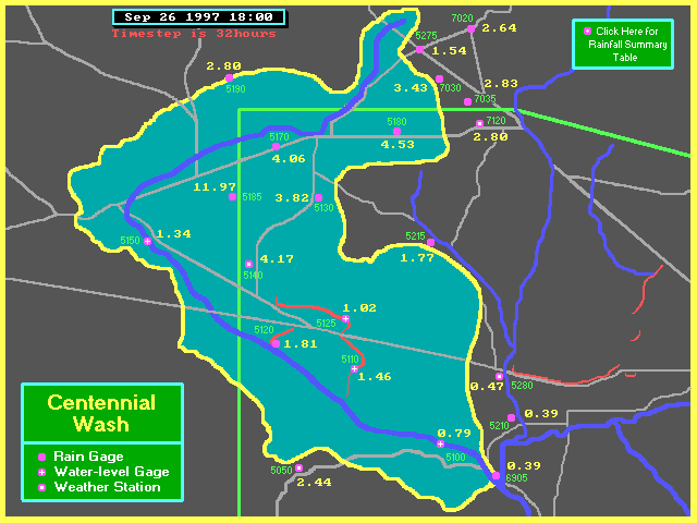
Figure 6: Centennial Wash Watershed
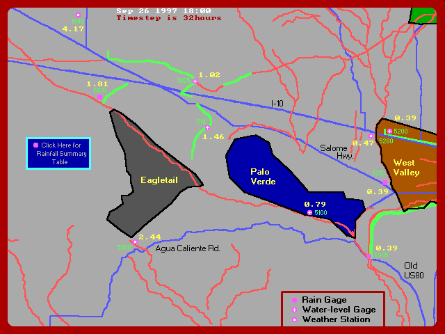
Figure 7: Eagletail and Palo Verde Forecast Zones
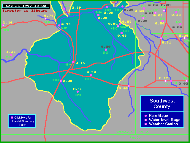
Figure 8: Waterman and Sauceda Wash Watersheds
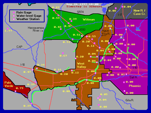
Figure 9: West Valley Forecast Zone
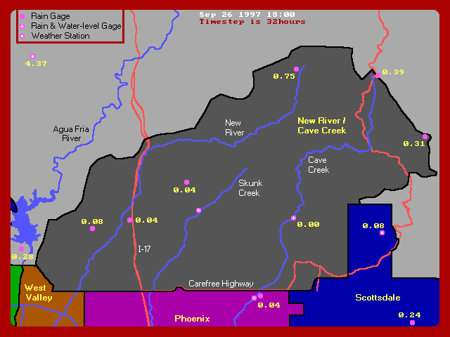
Figure 10: New River / Skunk Creek / Cave Creek Forecast Zone
Table 2
Additional Rainfall Reports from Airports and NWS Coop. Sites
|
STATION |
STORM TOTAL (inches) |
|
Alamo Lake State Park, AZ |
2.10 |
|
Blythe City, CA |
2.78 |
|
Blythe, CA Airport |
2.03 |
|
Calexico, CA |
3.30 |
|
Dateland Ranch, AZ |
1.80 |
|
Eagle Mountain, CA |
1.40 |
|
Ehrenberg, AZ |
1.06 |
|
El Centro, CA |
1.48 |
|
Imperial, CA Airport |
0.96 |
|
Iron Mountain, CA |
1.83 |
|
Niland, CA |
1.23 |
|
Ocotillo, CA |
1.88 |
|
Parker Reservoir, CA |
2.15 |
|
Salome, AZ |
3.60 |
|
Sky Harbor Airport, Phoenix, AZ |
0.03 |
|
Yuma Citrus Station, AZ |
2.02 |
|
Yuma Marine Corps Naval Air Station, AZ |
3.59 |
![]()
Rainfall intensities and volumes were high enough to cause runoff mainly in the southwest, west and northwestern portions of Maricopa County, as well as in the Hassayampa watershed in Yavapai County and in eastern La Paz County. Major watercourses which experienced significant flow events were the Hassayampa River, Sols Wash, Martinez Creek, Centennial Wash, Grass Wash, Jackrabbit Wash, Tiger Wash and Winters Wash. Table 4 lists recorded peak discharges and times at selected FCDMC and USGS stream gaging sites. Figure 11 shows a collage of storm hydrographs in the Wickenburg area.
The only Flood Control District structures significantly affected by Nora were in the Wickenburg area: Sunset FRS (39.5% full), Sunnycove FRS (13.9% full), and Casandro Dam (45.0% full). Table 3 lists the impoundment statistics for these dams.
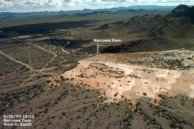
The big runoff story of TS Nora was Narrows Dam on Centennial Wash in La Paz County. The dam began filling around 5:00 PM on September 25th, reached the emergency spillway elevation (18.2 ft.) at around 3:30 PM on the 26th, and reached a maximum depth of 20.68 ft. at 8:50 PM on the 26th. The water surface remained fairly constant until 10:45 PM, when it started to fall noticeably. A falling-rate alarm sounded on the ALERT computer at 20 minutes after midnight on the 27th, and the water level fell below the emergency spillway elevation at approximately 1:25 AM. Unfortunately, FCD did not possess a stage/storage curve for the pool area, and thus was unable to determine whether the drop in water-surface was due to failure or spillway outflow. Field reconnaissance at daybreak on the 27th revealed two large breaches, one near the middle of the dam and one on the north end. Each breach was about 100 feet wide and probably caused by piping. At some point during the night the north breach captured the entire outflow from the pool area. The water level returned to its dry-state elevation (6.6 ft.) at approximately 4:00 AM on the 28th. Appendix 4 contains some digital photos of the dam and pool area in pre- and post failure condition, and Figure 12 compares the fill-hydrograph at Narrows Dam with the rainfall hyetograph from the Gladden rain gage.
TABLE 3:
Wickenburg Dam Impoundment Statistics
|
DAM |
Volume (ac-ft) |
% Full |
Stage (feet) |
|
Sunset FRS |
34 |
39.5 |
12.27 |
|
Sunnycove FRS |
30 |
13.9 |
17.19 |
|
Casandro Dam |
65 |
45.0 |
11.30 |
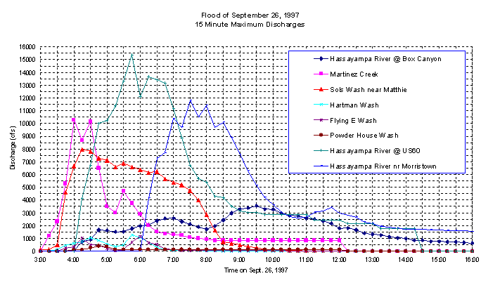
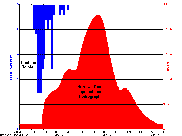
TABLE 4:
Recorded Peak Discharges and Times at Selected FCDMC and USGS Stream Gaging Sites|
Gage Name |
ID No. |
Peak Q (cfs) |
Date |
Time |
Peak Q Return Period (years) |
|
Centennial Wash above Narrows Dam |
NA |
8,100 (2) |
9/26/97 |
20:20 (1) |
7 |
|
Narrows Dam Outflow |
5153 |
2,610 |
9/26/97 |
20:50 |
NA |
|
Hassayampa R. @ US60 |
5228 |
15,376 |
9/26/97 |
05:30 (1) |
8 |
|
Hassayampa R. @ I-10 |
5283 |
7,440 |
9/26/97 |
15:00 (1) |
5 |
|
Hassayampa R. @ Box Canyon |
5308 |
3,549 |
9/26/97 |
09:21 |
<2 |
|
Martinez Creek |
7013 |
10,300 (3) |
9/26/97 |
04:28 |
20 |
|
Sols Wash nr Matthie |
7043 |
7,977 |
9/26/97 |
04:14 |
12 |
|
Hartman Wash @ US60 |
7063 |
1,253 |
9/26/97 |
05:44 |
6 |
|
Flying E Wash @ US60 |
7083 |
1,145 (3) |
9/26/97 |
05:51 |
12 |
|
Casandro Wash |
7093 |
177 (3) |
9/26/97 |
04:30 (1) |
20 |
|
Powderhouse Wash |
7113 |
387 |
9/26/97 |
04:43 |
13 |
|
Hassayampa R. near Morristown |
5223 09516500 |
11,800 |
9/26/97 |
07:30 |
6 |
|
Jackrabbit Wash |
09516800 |
9,710 (2) |
13 |
||
|
Hassayampa R. near Arlington |
09517000 |
2,900 |
9/26/97 |
16:30 (1) |
7 |
|
Tiger Wash |
09517280 |
8,000 (2) |
30 |
||
|
Centennial Wash @ SPRR |
5103 09517490 |
1,400 |
9/26/97 |
01:45 |
<2 |
![]()
ALERT SYSTEM PERFORMANCE
The overall performance of the ALERT system during this storm event was very good. All but one (Cave Creek at Cactus) of the 209 rain gages performed during the storm. All 82 weather sensors operated throughout the storm. However, pressure transducers did not fare as well with either partial or total failures at Casandro Wash, Casandro Dam, Sunnycove FRS, Hassayampa River at I-10 and Powderhouse Wash. Peak discharges and impoundment volumes at these sites were estimated from high-water marks, and in some cases checked by slope-area survey.
A record of ALERT alarms is presented in Table 5. Eleven rain gages and ten water-level gages reached ALERT alarm criteria during the storm. Warnings and information relayed by ALERT room staff included:
Table 5
Historical ALERT Alarm Log: Tropical Storm Nora
Alarm Action 1, Alarms: 0 3 5 6
ID Name TYPE and cause Date Time
--------------------------------------------------------------------------
5140 Tiger Wash Fan DEV rainfall rate 09/25/1997-15:44:16
5185 Harquahala Mtn. DEV rainfall rate 09/25/1997-15:58:26
7083 Flying E Wash DEV upper limit 09/25/1997-17:27:52
5103 Centennial Railroad DEV upper limit 09/26/1997-00:59:51
7025 Flores West DEV rainfall rate 09/26/1997-02:37:43
7010 Martinez Creek DEV rainfall rate 09/26/1997-03:19:31
7060 Hartman Wash DEV rainfall rate 09/26/1997-03:23:15
7070 Flying E Tank DEV rainfall rate 09/26/1997-03:29:37
7043 Sols Wsh nr Matthie DEV upper limit 09/26/1997-03:30:23
7120 Wickenburg Airport DEV rainfall rate 09/26/1997-03:33:28
7040 Sols Wsh nr Matthie DEV rainfall rate 09/26/1997-03:37:34
7063 Hartman Wash DEV upper limit 09/26/1997-03:39:59
7013 Martinez Creek DEV upper limit 09/26/1997-03:40:58
7090 Casandro Wash DEV rainfall rate 09/26/1997-03:41:22
5305 Hassy @ Box Canyon DEV rainfall rate 09/26/1997-03:43:33
7130 Casandro Dam DEV rainfall rate 09/26/1997-03:46:22
5233 Sunset FRS DEV upper limit 09/26/1997-03:56:27
5228 Hassayampa @ US60 DEV upper limit 09/26/1997-05:00:50
7133 Casandro Dam DEV upper limit 09/26/1997-05:49:55
5223 Hassy nr Morristown DEV upper limit 09/26/1997-06:09:43
5153 Narrows Dam DEV upper limit 09/26/1997-12:06:10
5153 Narrows Dam DEV falling rate 09/27/1997-00:19:49
Note: Many of the above alarms occurred more than once, in which case only the first occurrence is listed.
Stations that would have alarmed but were inoperable during the event:
5283 Hassayampa R. @ I-10
![]()
This report presented rainfall, discharge and impoundment data from the Flood Control District's ALERT data collection system and other sources for Tropical Storm Nora, September 25-26, 1997. The greatest rainfall amounts were recorded in the western and west-central portions of the County. Significant runoff events occurred on several small and medium-sized washes in the Wickenburg area, as well as on the Hassayampa River, Tiger Wash, Jackrabbit Wash and Centennial Wash. Narrows Dam on Centennial Wash near Salome breached as a result of the impoundment from this and possibly previous storms in August. The performance of the ALERT system was exemplary, allowing operators to disseminate advisories and information in a timely manner according to District policy.
Observations for future consideration:
To minimize the occurrence of a similar situation, staff must be sure to have an accurate stage/storage table for each instrumented dam, and should create for each instrumented dam a graph showing a typical fill/drain hydrograph versus a failure hydrograph.
![]()
Appendix A: NWS Advisories, Watches, and Warnings
BULLETIN - EAS ACTIVATION REQUESTED
FLASH FLOOD WARNING
NATIONAL WEATHER SERVICE PHOENIX AZ
708 PM MST THU SEP 25 1997
FLASH FLOOD WARNING FOR
NORTHWESTERN MARICOPA COUNTY IN CENTRAL ARIZONA
NORTHERN AND EAST CENTRAL LA PAZ COUNTY IN WEST CENTRAL ARIZONA
UNTIL 9:00 PM MST
SOME LOCATIONS AFFECTED
AGUILA
GLADDEN
WICKENBURG
VICKSBURG
SALOME
WENDEN
ALAMO STATE PARK
AT 705 PM MST RADAR CONTINUED TO SHOW MODERATE TO LOCALLY HEAVY RAIN CONTINUEING OVER THE WARNING AREA. IN ADDITION AUTOMATIC RAIN GAGES IN THE WARNING AREA WERE RECEIVING IN EXCESS OF THREE-QUARTERS /0.75/ OF AN INCH OF RAIN PER HOUR. AS A RESULT…FLASH FLOODING IS OCCURRING OR IMMINENT IN THE WARNING LOCATIONS.
BULLETIN
TROPICAL DEPRESSION NORA ADVISORY NUMBER 30
NATIONAL WEATHER SERVICE MIAMI FL
8 PM PDT THU SEP 25 1997
… NORA DYING OVER THE SOUTHWESTERN UNITED STATES…STILL A HEAVY RAIN THREAT…
NORA HAS WEAKENED TO A TROPICAL DEPRESSION AND IS EXPECTED TO DISSIPATE IN A DAY OR SO.
AT 8 PM PDT …0300Z… THE CENTER OF TROPICAL DEPRESSION NORA WAS LOCATED NEAR LATITUDE 35.0 NORTH… LONGITUDE 114.7 WEST OR ABOUT 50 MILES WEST-SOUTHWEST OF KINGMAN ARIZONA.
NORA IS MOVING TOWARD THE NORTH NEAR 25 MPH AND A GRADUAL TURN TOWARD THE NORTH-NORTHEAST IS EXPECTED DURING THE NEXT 24 HOURS.
ESTIMATED MINIMUM CENTRAL PRESSURE IS 998 MB… 29.47 INCHES.
ADDITIONAL RAINFALL TOTALS OF 1 TO 3 INCHES… WITH ISOLATED LARGER AMOUNTS ARE POSSIBLE IN ASSOCIATION WITH NORA. HEAVIEST RAINS ARE NORTH AND EAST OF THE CENTER. THIS ACTIVITY WILL CONTINUE TO SPREAD NORTHWARD AND NORTHEASTWARD… AND COULD CAUSE LIFE-THREATENING FLASH FLOODS AND MUD SLIDES. SEE STATEMENTS FROM LOCAL NATIONAL WEATHER SERVICE OFFICES.
THIS IS THE LAST PUBLIC ADVISORY ISSUED BY THE NATIONAL HURRICANE CENTER ON NORA.
FLASH FLOOD STATEMENT
NATIONAL WEATHER SERVICE PHOENIX AZ
906 PM MST THU SEP 25 1997
…FLASH FLOOD WARNING FOR NORTHWEST MARICOPA AND PORTIONS OF NORTHERN AND EAST CENTRAL LA PAZ COUNTIES EXPIRED…
AT 855 PM PHOENIX AND YUMA DOPPLER RADAR SHOWED THE FOCUS OF THE HEAVIEST RAINS HAD SHIFTED INTO MOHAVE AND YAVAPAI COUNTIES.. WITH MOSTLY SPOTTY LIGHT SHOWERS OR SPRINKLES CONTINUING OVER LA PAZ AND NORTHWEST LA PAZ COUNTIES. THUS THE WARNING ISSUED EARLIER WAS ALLOWED TO EXPIRE.
ALTHOUGH THE RAIN HAS TAPERED OFF FOR THE MOST PART… WASHES WILL CONTINUE RUNNING IN THE AREA AND FLOODING OF SECONDARY ROADS WILL PERSIST UNTIL AT LEAST 11 PM.. THUS AN URBAN AND SMALL STREAM FLOOD ADVISORY WILL BE ISSUED SHORTLY FOR NORTHWEST MARICOPA AND PORTIONS OF NORTHERN AND EAST CENTRAL LA PAZ COUNTIES.
HEAVY RAIN BETWEEN 7 AND 8 PM CAUSED EXTENSIVE FLOODING IN THE TOWN OF AGUILA.. WITH REPORTS OF SIX INCHES OF STANDING WATER ON SOME PROPERTIES AND ROADS. THERE WAS ALSO WATER FLOWING ACROSS EAGLE EYE ROAD IN WESTERN AGUILA.
URBAN AND SMALL STREAM FLOOD ADVISORY
NATIONAL WEATHER SERVICE PHOENIX AZ
1101 PM MST THU SEP 25 1997
…URBAN AND SMALL STREAM FLOOD ADVISORY FOR NORTHWEST MARICOPA AND PORTIONS OF NORTHERN AND EAST CENTRAL LA PAZ COUNTIES EXPIRED…
ISOLATED SHOWERS WILL PERSIST OVER PORTIONS OF LA PAZ AND MARICOPA COUNTIES. THE SHOWERS WERE MOVING RAPIDLY NORTH… NEAR 25 MPH. THUS ANY HEAVY SHOWERS THAT FORM OR MOVE ACROSS THE AREA ARE EXPECTED TO BE BRIEF. ADDITIONAL RAINFALL AMOUNTS ARE ANTICIPATED TO AVERAGE UNDER A QUARTER OF AN INCH THROUGH 1 AM… HOWEVER THERE COULD BE LOCALLY HIGHER AMOUNTS WHERE HEAVY SHOWERS MOVE ACROSS. OTHERWISE SIGNIFICANT RAIN IS NOT EXPECTED TO FALL ACROSS THE AREA THROUGH EARLY FRIDAY MORNING… THUS THE ADVISORY WAS ALLOWED TO EXPIRE.
ALTHOUGH SHOWERS HAVE BECOME ISOLATED AND MOSTLY LIGHT… WASHES IN THE AREA WILL CONTINUE RUNNING DURING THE NIGHT.
BULLETIN - EAS ACTIVATION REQUESTED
FLASH FLOOD WARNING
NATIONAL WEATHER SERVICE PHOENIX AZ
352 AM MST FRI SEP 26 1997
FLASH FLOOD WARNING FOR NORTHWESTERN MARICOPA COUNTY IN CENTRAL ARIZONA UNTIL 645 AM MST
SOME LOCATIONS AFFECTED
WICKENBURG AND AGUILA
STATE ROUTE 71 AND US HIGHWAY 60 IN NORTHERN MARICOPA COUNTY
AT 345 AM MST RADAR ESTIMATED RAINFALL RATES OF 1 TO 2 INCHES DURING THE PAST 2 TO 3 HOURS IN NORTHWEST MARICOPA COUNTY. AS A RESULT… FLASH FLOODING IS OCCURRING OR IMMINENT IN THE WARNING LOCATIONS.
AT 330 AM A SPOTTER IN WICKENBURG REPORTED WASHES RUNNING ALONG WITH 2 INCHES OF RAINFALL SINCE THURSDAY AFTERNOON.
RESIDENTS OF WICKENBURG SHOULD USE CAUTION IF TRAVEL IS NECESSARY EARLY THIS MORNING… AS SOME SECONDARY ROADS IN LOW-LYING AREAS MAY BE COVERED BY FLOODWATERS.
BULLETIN - EAS ACTIVATION REQUESTED
FLASH FLOOD WARNING
NATIONAL WEATHER SERVICE PHOENIX AZ
640 AM MST FRI SEP 26 1997
FLASH FLOOD WARNING FOR NORTHWESTERN MARICOPA COUNTY IN CENTRAL ARIZONA
UNTIL 800 AM MST
SOME LOCATIONS AFFECTED
WICKENBURG AND SOUTHWARD ALONG THE HASSAYAMPA RIVER TO MORRISTOWN
AT 600 AM MST WICKENBURG POLICE REPORTED SOME EVACUATIONS TAKING PLACE NEAR SOLS WASH IN WICKENBURG. FLASH FLOODING IS LIKELY TO CONTINUE IN THE WARNED AREA AS UP TO 4 INCHES OF RAIN WAS REPORTED IN WICKENBURG SINCE LATE THURSDAY.
PEOPLE IN WICKENBURG SHOULD MONITOR FLOOD CONDITIONS… AND BE PREPARED TO MOVE TO HIGHER GROUND… SHOULD FLOODWATERS THREATEN.
PUBLIC INFORMATION STATEMENT
NATIONAL WEATHER SERVICE PHOENIX AZ
305 PM MST FRI SEP 26 1997
… NORA PRODUCES LOCALLY HEAVY RAIN AND FLASH FLOODING OVER PORTIONS OF FAR SOUTHEAST CALIFORNIA AND WESTERN ARIZONA…
ON THURSDAY… NORA BECAME THE THIRD TROPICAL STORM TO AFFECT ARIZONA THIS CENTURY. THE OTHER TWO TROPICAL STORMS TO AFFECT ARIZONA WERE JOANNE (OCTOBER 1972) AND KATHLEEN (SEPTEMBER 1976). BY DEFINITION… TROPICAL STORMS POSSESS MAXIMUM SUSTAINED SURFACE WINDS RANGING FROM 39 TO 73 MPH. NORA WAS DOWNGRADED FROM A HURRICANE TO A TROPICAL STORM THURSDAY MORNING AFTER CROSSING THE NORTHERN BAJA PENINSULA. NORA CONTINUED TO WEAKEN AND ACCELERATED AS SHE MOVED NORTH INTO THE SOUTHWEST UNITED STATES.
AS NORA PASSED NEAR YUMA THURSDAY AFTERNOON… WINDS WERE SUSTAINED AT 40 MPH WITH GUSTS IN EXCESS OF 50 MPH BETWEEN 2 AND 3 PM. ALTHOUGH NORA CONTINUED TO WEAKEN… SHE OFFICIALLY MAINTAINED TROPICAL STORM STATUS DURING THE REMAINDER OF THE AFTERNOON WHILE TRACKING NORTH ALONG THE LOWER COLORADO RIVER. BY 8 PM… NORA WAS CENTERED 50 MILES WEST-SOUTHWEST OF KINGMAN… AND HAD BEEN DOWNGRADED TO A TROPICAL DEPRESSION.
ALTHOUGH MUCH OF THE PHOENIX METROPOLITAN AREA RECEIVED LITTLE RAIN AND MINIMAL WIND FROM TROPICAL STORM NORA… A SIGNIFICANT RAINFALL EVENT OCCURRED OVER A LARGE PROTION OF WESTERN AND NORTH-CENTRAL ARIZONA AS WELL AS OVER FAR SOUTHEAST CALIFORNIA. RAINFALLS OF 1 TO 4 INCHES WERE COMMON OVER THIS AREA… WITH LOCAL AMOUNTS IN EXCESS OF 5 INCHES. SEVERAL LOCATIONS ALONG OR NEAR THE LOWER COLORADO RIVER… INCLUDING YUMA… RECEIVED AS MUCH RAIN FROM NORA AS THEY TYPICALLY EXPERIENCE DURING AN ENTIRE YEAR.
SOME RAINFALL AMOUNTS FROM SOUTHEAST CALIFORNIA AND WESTERN ARIZONA SITES INCLUDE:
MARICOPA COUNTY ARIZONA
WICKENBURG (15 MILES WEST) 4.53 INCHES
GLADDEN 4.02
AGUILA (11 MILES SOUTH) 3.82
GILA BEND MTNS (16NW OF PAINTED ROCK) 2.44
WICKENBURG AIRPORT 2.20
WITTMAN (2 MILES NORTHEAST) 1.73
TONOPAH (7 MILES WEST OF TONOPAH) 1.46
LA PAZ COUNTY ARIZONA
HARQUAHALA MTN 5.97
CENTENNIAL WASH (19 MI W WICKENBURG) 4.21
SMITH PEAK (HARCUVAR MTNS) 2.17
PARKER 1.39
YUMA COUNTY ARIZONA
YUMA 3.83
DATELAND 2.80
IMPERIAL COUNTY CALIFORNIA
IMPERIAL 0.69
RIVERSIDE COUNTY CALIFORNIA
BLYTHE 1.66
SOUTH-CENTRAL SAN BERNADINO COUNTY CALIFORNIA
TWENTYNINE PALMS 2.40
JOSHUA TREE NATIONAL PARK 2.00
FLASH FLOODING WAS REPORTED OVER PORTIONS OF YUMA AND LA PAZ COUNTIES THURSDAY … AND OVER PORTIONS OF LA PAZ AND NORTHWEST MARICOPA COUNTIES THURSDAY NIGHT AND FRIDAY MORNING. SOME LOCATIONS AFFECTED BY FLASH FLOODING INCLUDE SOMERTON … YUMA … VICKSBURG … PARKER … WICKENBURG … AND AGUILA.
![]()
Appendix B: Hourly Precipitation Amounts for Selected Automatic Stations
Storm Period:
September 25th 10:00 AM through
September 26th 6:00 PM
FCD of Maricopa County ALERT System
Precip 1 : Lower Gila/Centennial
DeviceID 5000 5050 5100 5110 5120 5125
Hourly Rainfall Values in Inches
09/26/97
1800 0.00 0.00 0.00 0.00 0.00 0.00
1700 0.00 0.00 0.00 0.00 0.00 0.00
1600 0.00 0.00 0.00 0.00 0.00 0.00
1500 0.00 0.00 0.00 0.00 0.00 0.00
1400 0.00 0.00 0.00 0.00 0.00 0.00
1300 0.00 0.00 0.00 0.00 0.00 0.00
1200 0.00 0.00 0.00 0.00 0.00 0.00
1100 0.00 0.00 0.00 0.00 0.00 0.00
1000 0.00 0.00 0.00 0.00 0.00 0.00
0900 0.00 0.00 0.00 0.00 0.00 0.00
0800 0.00 0.00 0.00 0.00 0.00 0.00
0700 0.00 0.00 0.00 0.00 0.00 0.00
0600 0.00 0.00 0.00 0.00 0.00 0.00
0500 0.00 0.00 0.00 0.00 0.04 0.00
0400 0.00 0.00 0.00 0.00 0.00 0.00
0300 0.00 0.00 0.00 0.00 0.00 0.00
0200 0.00 0.00 0.00 0.00 0.00 0.00
0100 0.00 0.00 0.00 0.00 0.00 0.00
09/25/97
2400 0.00 0.00 0.00 0.00 0.00 0.00
2300 0.00 0.00 0.00 0.00 0.00 0.00
2200 0.00 0.00 0.00 0.00 0.00 0.00
2100 0.04 0.00 0.00 0.00 0.00 0.00
2000 0.00 0.00 0.00 0.00 0.04 0.00
1900 0.00 0.00 0.00 0.08 0.00 0.04
1800 0.00 0.04 0.00 0.04 0.04 0.12
1700 0.04 0.63 0.08 0.35 0.39 0.20
1600 0.28 0.67 0.12 0.59 0.55 0.43
1500 0.35 0.63 0.24 0.16 0.31 0.16
1400 0.20 0.12 0.24 0.16 0.28 0.00
1300 0.20 0.20 0.12 0.08 0.16 0.08
1200 0.16 0.16 0.00 0.00 0.00 0.00
1100 0.00 0.00 0.00 0.00 0.00 0.00
TOTALS: 1.26 2.44 0.79 1.46 1.81 1.02
FCD of Maricopa County ALERT System
Precip 2 : Upper Centennial
DeviceID 5130 5140 5150 5170 5180 5185 5190
Hourly Rainfall Values in Inches
09/26/97
1800 0.00 0.00 0.00 0.00 0.00 0.00 0.00
1700 0.00 0.00 0.00 0.00 0.00 0.00 0.00
1600 0.00 0.00 0.00 0.00 0.00 0.00 0.00
1500 0.00 0.00 0.00 0.00 0.00 0.00 0.28
1400 0.00 0.00 0.00 0.00 0.00 0.00 0.31
1300 0.00 0.00 0.00 0.00 0.00 0.00 0.00
1200 0.00 0.00 0.00 0.00 0.00 0.00 0.00
1100 0.00 0.00 0.00 0.00 0.00 0.00 0.00
1000 0.00 0.00 0.00 0.00 0.00 0.00 0.00
0900 0.00 0.00 0.00 0.00 0.00 0.00 0.00
0800 0.00 0.00 0.00 0.00 0.00 0.00 0.00
0700 0.00 0.00 0.00 0.04 0.00 0.00 0.04
0600 0.00 0.00 0.00 0.00 0.31 0.08 0.00
0500 0.28 0.04 0.00 0.08 0.63 0.43 0.00
0400 0.47 0.16 0.00 0.04 0.20 0.67 0.00
0300 0.20 0.47 0.04 0.08 0.67 0.28 0.00
0200 0.55 1.14 0.00 0.00 0.79 0.24 0.00
0100 0.24 0.08 0.00 0.00 0.08 0.08 0.00
09/25/97
2400 0.08 0.20 0.00 0.08 0.00 0.79 0.00
2300 0.08 0.04 0.00 0.51 0.12 1.30 0.08
2200 0.24 0.12 0.04 0.12 0.04 0.67 0.08
2100 0.04 0.04 0.12 0.20 0.00 0.63 0.08
2000 0.08 0.00 0.04 0.12 0.08 0.87 0.28
1900 0.08 0.00 0.12 0.43 0.39 1.42 0.51
1800 0.16 0.08 0.43 0.51 0.20 1.61 0.47
1700 0.43 0.35 0.08 0.71 0.43 0.75 0.35
1600 0.47 0.71 0.12 0.71 0.28 1.30 0.12
1500 0.24 0.31 0.12 0.24 0.24 0.39 0.16
1400 0.20 0.35 0.16 0.20 0.08 0.31 0.04
1300 0.00 0.08 0.08 0.00 0.00 0.16 0.00
1200 0.00 0.00 0.00 0.00 0.00 0.00 0.00
1100 0.00 0.00 0.00 0.00 0.00 0.00 0.00
TOTALS: 3.82 4.17 1.34 4.06 4.53 11.97 2.80
FCD of Maricopa County ALERT System
Precip 3 : Lower Hassayampa
DeviceID 5200 5205 5210 5215 5220 5225
Hourly Rainfall Values in Inches
09/26/97
1800 0.00 0.00 0.00 0.00 0.00 0.00
1700 0.00 0.00 0.00 0.00 0.00 0.00
1600 0.00 0.00 0.00 0.04 0.00 0.00
1500 0.00 0.00 0.00 0.00 0.00 0.00
1400 0.00 0.00 0.00 0.00 0.00 0.00
1300 0.00 0.00 0.00 0.00 0.00 0.00
1200 0.00 0.00 0.00 0.00 0.00 0.00
1100 0.00 0.00 0.00 0.00 0.00 0.00
1000 0.00 0.00 0.00 0.00 0.00 0.16
0900 0.00 0.00 0.00 0.00 0.08 0.00
0800 0.00 0.00 0.00 0.00 0.28 0.00
0700 0.00 0.00 0.00 0.00 0.00 0.24
0600 0.00 0.00 0.00 0.00 0.00 0.28
0500 0.00 0.00 0.00 0.00 0.00 0.63
0400 0.00 0.00 0.00 0.04 0.00 0.28
0300 0.00 0.00 0.00 0.20 0.00 0.12
0200 0.00 0.00 0.00 0.00 0.00 0.08
0100 0.00 0.00 0.00 0.00 0.00 0.04
09/25/97
2400 0.00 0.00 0.00 0.00 0.00 0.00
2300 0.00 0.00 0.00 0.00 0.00 0.00
2200 0.00 0.00 0.00 0.00 0.00 0.04
2100 0.00 0.00 0.00 0.00 0.04 0.08
2000 0.00 0.00 0.00 0.08 0.08 0.20
1900 0.00 0.00 0.00 0.20 0.00 0.04
1800 0.00 0.00 0.00 0.20 0.04 0.04
1700 0.04 0.08 0.00 0.24 0.24 0.35
1600 0.08 0.04 0.08 0.35 0.04 0.20
1500 0.16 0.00 0.16 0.28 0.08 0.08
1400 0.12 0.04 0.12 0.16 0.00 0.04
1300 0.00 0.00 0.04 0.00 0.00 0.00
1200 0.00 0.00 0.00 0.00 0.00 0.00
1100 0.00 0.00 0.00 0.00 0.00 0.00
TOTALS: 0.39 0.16 0.39 1.77 0.87 2.87
FCD of Maricopa County ALERT System
Precip 4 : Middle Hassayampa
DeviceID 5230 5245 5260 5275 5280 5290 5305
Hourly Rainfall Values in Inches
09/26/97
1800 0.00 0.00 0.00 0.00 0.00 0.00 0.00
1700 0.00 0.00 0.00 0.00 0.00 0.00 0.00
1600 0.00 0.00 0.00 0.00 0.00 0.00 0.00
1500 0.00 0.00 0.00 0.00 0.00 0.00 0.00
1400 0.00 0.00 0.00 0.00 0.00 0.00 0.00
1300 0.00 0.00 0.04 0.00 0.00 0.00 0.00
1200 0.00 0.00 0.08 0.39 0.00 0.00 0.00
1100 0.00 0.00 0.12 0.08 0.00 0.00 0.00
1000 0.20 0.12 0.16 0.00 0.00 0.04 0.00
0900 0.04 0.04 0.28 0.00 0.00 0.00 0.00
0800 0.00 0.00 0.35 0.00 0.00 0.04 0.00
0700 0.08 0.08 0.31 0.00 0.00 0.16 0.39
0600 0.51 0.35 0.24 0.00 0.00 0.16 0.51
0500 0.55 0.51 0.24 0.04 0.00 0.28 0.71
0400 0.47 0.28 0.08 0.04 0.00 0.20 1.10
0300 0.04 0.12 0.04 0.04 0.00 1.38 0.08
0200 0.04 0.04 0.08 0.08 0.00 0.87 0.08
0100 0.04 0.04 0.04 0.08 0.00 0.51 0.00
09/25/97
2400 0.04 0.04 0.00 0.04 0.00 0.31 0.04
2300 0.00 0.00 0.04 0.08 0.00 0.59 0.00
2200 0.04 0.00 0.08 0.08 0.00 0.20 0.04
2100 0.12 0.12 0.08 0.08 0.00 0.55 0.08
2000 0.20 0.24 0.16 0.12 0.00 0.98 0.47
1900 0.12 0.08 0.12 0.12 0.00 0.00 0.00
1800 0.04 0.04 0.04 0.08 0.00 0.00 0.00
1700 0.31 0.31 0.24 0.08 0.04 0.16 0.20
1600 0.20 0.24 0.20 0.08 0.08 0.12 0.16
1500 0.08 0.12 0.08 0.04 0.16 0.04 0.04
1400 0.04 0.00 0.04 0.00 0.16 0.08 0.08
1300 0.00 0.00 0.00 0.00 0.04 0.00 0.00
1200 0.00 0.00 0.00 0.00 0.00 0.00 0.00
1100 0.00 0.00 0.00 0.00 0.00 0.00 0.00
TOTALS: 3.15 2.76 3.11 1.54 0.47 6.65 3.98
FCD of Maricopa County ALERT System
Precip 5 : Wickenburg 1
DeviceID 7000 7005 7010 7020 7025 7030
Hourly Rainfall Values in Inches
09/26/97
1800 0.00 0.00 0.00 0.00 0.00 0.00
1700 0.00 0.00 0.00 0.00 0.00 0.00
1600 0.00 0.00 0.00 0.00 0.00 0.00
1500 0.00 0.00 0.00 0.00 0.00 0.00
1400 0.00 0.00 0.00 0.00 0.00 0.00
1300 0.00 0.00 0.00 0.00 0.00 0.00
1200 0.00 0.00 0.00 0.00 0.00 0.00
1100 0.00 0.00 0.00 0.00 0.00 0.04
1000 0.00 0.00 0.00 0.00 0.04 0.00
0900 0.04 0.04 0.00 0.00 0.00 0.00
0800 0.00 0.00 0.00 0.00 0.00 0.00
0700 0.16 0.08 0.08 0.04 0.00 0.00
0600 0.24 0.16 0.47 0.12 0.20 0.24
0500 0.12 0.16 0.24 0.04 0.55 0.28
0400 0.31 0.12 0.94 0.04 0.04 0.04
0300 0.43 0.71 0.35 0.31 1.22 0.28
0200 0.12 0.43 0.00 0.47 0.47 0.55
0100 0.08 0.08 0.04 0.08 0.04 0.04
09/25/97
2400 0.12 0.04 0.04 0.08 0.04 0.04
2300 0.28 0.24 0.08 0.24 0.08 0.12
2200 0.04 0.00 0.00 0.04 0.04 0.00
2100 0.31 0.16 0.08 0.16 0.08 0.00
2000 0.43 0.47 0.16 0.28 0.20 0.43
1900 0.00 0.12 0.08 0.04 0.04 0.16
1800 0.04 0.12 0.12 0.20 0.20 0.43
1700 0.24 0.24 0.35 0.31 0.35 0.31
1600 0.08 0.12 0.28 0.12 0.20 0.31
1500 0.08 0.08 0.08 0.08 0.08 0.12
1400 0.04 0.04 0.04 0.00 0.04 0.04
1300 0.00 0.00 0.00 0.00 0.00 0.00
1200 0.00 0.00 0.00 0.00 0.00 0.00
1100 0.00 0.00 0.00 0.00 0.00 0.00
TOTALS: 3.15 3.39 3.43 2.64 3.90 3.43
FCD of Maricopa County ALERT System
Precip 6 : Wickenburg 2
DeviceID 7035 7040 7050 7060 7070 7080
Hourly Rainfall Values in Inches
09/26/97
1800 0.00 0.00 0.00 0.00 0.00 0.00
1700 0.00 0.00 0.00 0.00 0.00 0.00
1600 0.00 0.00 0.00 0.00 0.00 0.00
1500 0.00 0.00 0.00 0.00 0.00 0.00
1400 0.00 0.00 0.00 0.00 0.00 0.00
1300 0.00 0.00 0.00 0.00 0.00 0.00
1200 0.00 0.00 0.00 0.00 0.00 0.00
1100 0.00 0.00 0.00 0.00 0.00 0.00
1000 0.00 0.00 0.00 0.00 0.00 0.08
0900 0.00 0.00 0.00 0.00 0.08 0.00
0800 0.00 0.00 0.00 0.00 0.00 0.00
0700 0.04 0.12 0.00 0.24 0.04 0.16
0600 0.16 0.31 0.12 0.24 0.39 0.71
0500 0.20 0.16 0.20 0.28 0.24 0.08
0400 0.04 1.02 0.51 1.10 0.79 0.39
0300 0.43 0.08 0.16 0.12 0.04 0.04
0200 0.04 0.00 0.08 0.08 0.04 0.04
0100 0.08 0.00 0.04 0.00 0.04 0.08
09/25/97
2400 0.00 0.04 0.04 0.04 0.04 0.00
2300 0.16 0.08 0.16 0.12 0.16 0.04
2200 0.04 0.04 0.12 0.04 0.00 0.04
2100 0.12 0.16 0.04 0.04 0.04 0.20
2000 0.28 0.08 0.35 0.16 0.20 0.12
1900 0.04 0.12 0.12 0.08 0.08 0.12
1800 0.24 0.16 0.35 0.24 0.16 0.16
1700 0.43 0.31 0.24 0.35 0.39 0.28
1600 0.35 0.16 0.28 0.31 0.35 0.28
1500 0.16 0.08 0.20 0.16 0.16 0.12
1400 0.04 0.04 0.04 0.08 0.08 0.08
1300 0.00 0.00 0.00 0.00 0.00 0.00
1200 0.00 0.00 0.00 0.00 0.00 0.00
1100 0.00 0.00 0.00 0.00 0.00 0.00
TOTALS: 2.83 2.95 3.03 3.66 3.31 2.99
FCD of Maricopa County ALERT System
Precip 7 : Wickenburg 3
DeviceID 7090 7100 7110 7120 7130
Hourly Rainfall Values in Inches
09/26/97
1800 0.00 0.00 0.00 0.00 0.00
1700 0.00 0.00 0.00 0.00 0.00
1600 0.00 0.00 0.00 0.00 0.00
1500 0.00 0.00 0.00 0.00 0.00
1400 0.00 0.00 0.00 0.00 0.00
1300 0.00 0.00 0.00 0.00 0.00
1200 0.00 0.00 0.12 0.00 0.00
1100 0.00 0.00 0.12 0.20 0.00
1000 0.04 0.04 0.24 0.00 0.24
0900 0.04 0.00 0.12 0.00 0.00
0800 0.00 0.00 0.24 0.00 0.00
0700 0.24 0.24 0.28 0.00 0.08
0600 0.87 0.20 0.24 0.39 0.83
0500 0.16 0.83 0.24 0.12 0.43
0400 0.83 0.12 0.12 0.94 0.67
0300 0.04 0.16 0.12 0.04 0.04
0200 0.08 0.00 0.00 0.04 0.04
0100 0.04 0.04 0.00 0.00 0.04
09/25/97
2400 0.00 0.04 0.04 0.04 0.04
2300 0.08 0.08 0.00 0.04 0.00
2200 0.00 0.00 0.20 0.00 0.04
2100 0.24 0.00 0.16 0.08 0.12
2000 0.12 0.16 0.00 0.08 0.28
1900 0.28 0.00 0.08 0.08 0.12
1800 0.12 0.04 0.12 0.12 0.08
1700 0.31 0.24 0.12 0.24 0.35
1600 0.28 0.12 0.12 0.24 0.20
1500 0.20 0.04 0.00 0.12 0.12
1400 0.00 0.04 0.00 0.04 0.00
1300 0.00 0.00 0.00 0.00 0.00
1200 0.00 0.00 0.00 0.00 0.00
1100 0.00 0.00 0.00 0.00 0.00
TOTALS: 3.94 2.36 2.64 2.80 3.70
FCD of Maricopa County ALERT System
Precip 8 : Upper Hassayampa
DeviceID 5320 5335 5340 5350 5365 5380
Hourly Rainfall Values in Inches
09/26/97
1800 0.00 0.00 0.00 0.00 0.00 0.00
1700 0.00 0.16 0.00 0.00 0.00 0.00
1600 0.00 0.00 0.00 0.00 0.00 0.00
1500 0.00 0.00 0.00 0.00 0.00 0.00
1400 0.00 0.00 0.00 0.00 0.00 0.00
1300 0.00 0.00 0.00 0.00 0.00 0.04
1200 0.00 0.00 0.04 0.00 0.00 0.08
1100 0.08 0.00 0.00 0.04 0.00 0.35
1000 0.00 0.00 0.04 0.12 0.31 0.12
0900 0.00 0.00 0.00 0.00 0.43 0.04
0800 0.00 0.04 0.12 0.08 0.35 0.31
0700 0.35 0.04 0.20 0.16 0.28 0.24
0600 0.75 0.63 0.75 0.12 0.47 0.16
0500 0.63 0.28 0.71 0.28 0.28 0.35
0400 0.67 0.12 0.12 0.20 0.55 0.59
0300 0.20 0.08 0.04 0.12 1.22 0.28
0200 0.00 0.04 0.08 0.20 0.28 0.24
0100 0.08 0.16 0.16 0.04 0.04 0.20
09/25/97
2400 0.08 0.12 0.20 0.20 0.12 0.24
2300 0.04 0.04 0.08 0.12 0.00 0.12
2200 0.00 0.28 0.20 0.00 0.12 0.39
2100 0.31 0.12 0.12 0.59 0.39 0.20
2000 0.08 0.04 0.08 0.28 0.16 0.04
1900 0.04 0.08 0.08 0.04 0.04 0.12
1800 0.12 0.28 0.31 0.24 0.24 0.16
1700 0.20 0.24 0.16 0.16 0.04 0.16
1600 0.08 0.24 0.12 0.08 0.04 0.08
1500 0.00 0.00 0.04 0.00 0.04 0.04
1400 0.00 0.00 0.00 0.00 0.00 0.04
1300 0.00 0.00 0.00 0.00 0.00 0.00
1200 0.00 0.00 0.00 0.00 0.00 0.00
1100 0.00 0.00 0.00 0.00 0.00 0.00
TOTALS: 3.70 2.95 3.62 3.03 5.39 4.57
FCD of Maricopa County ALERT System
Precip 9 : McMicken
DeviceID 5400 5405 5410 5415 5430 5435 5445 5450
Hourly Rainfall Values in Inches
09/26/97
1800 0.00 0.04 0.00 0.00 0.00 0.00 0.00 0.00
1700 0.00 0.00 0.00 0.00 0.00 0.00 0.00 0.00
1600 0.00 0.00 0.00 0.00 0.00 0.00 0.00 0.00
1500 0.00 0.00 0.00 0.00 0.00 0.00 0.00 0.00
1400 0.00 0.00 0.00 0.00 0.00 0.00 0.00 0.00
1300 0.00 0.00 0.00 0.00 0.00 0.00 0.00 0.00
1200 0.00 0.00 0.00 0.00 0.00 0.00 0.00 0.00
1100 0.00 0.00 0.00 0.00 0.00 0.00 0.00 0.00
1000 0.00 0.00 0.00 0.00 0.00 0.00 0.00 0.00
0900 0.00 0.00 0.00 0.00 0.00 0.00 0.00 0.00
0800 0.00 0.00 0.00 0.00 0.00 0.00 0.00 0.00
0700 0.00 0.00 0.00 0.00 0.00 0.00 0.00 0.00
0600 0.00 0.00 0.00 0.00 0.08 0.00 0.00 0.00
0500 0.00 0.00 0.00 0.04 0.08 0.00 0.00 0.00
0400 0.00 0.00 0.00 0.00 0.04 0.00 0.00 0.00
0300 0.00 0.00 0.00 0.00 0.00 0.00 0.00 0.00
0200 0.00 0.00 0.00 0.00 0.00 0.00 0.00 0.00
0100 0.00 0.00 0.00 0.00 0.00 0.00 0.00 0.00
09/25/97
2400 0.00 0.00 0.00 0.00 0.00 0.00 0.00 0.00
2300 0.00 0.00 0.00 0.00 0.00 0.00 0.00 0.00
2200 0.00 0.00 0.00 0.00 0.00 0.00 0.00 0.00
2100 0.00 0.00 0.00 0.00 0.00 0.00 0.00 0.08
2000 0.00 0.00 0.00 0.00 0.00 0.00 0.00 0.00
1900 0.00 0.00 0.00 0.00 0.04 0.00 0.00 0.00
1800 0.00 0.00 0.00 0.00 0.00 0.28 0.20 0.00
1700 0.00 0.00 0.00 0.16 0.24 0.24 0.28 0.12
1600 0.00 0.00 0.04 0.00 0.08 0.04 0.04 0.08
1500 0.00 0.00 0.00 0.00 0.04 0.00 0.00 0.12
1400 0.00 0.00 0.00 0.00 0.08 0.00 0.00 0.04
1300 0.00 0.00 0.00 0.00 0.00 0.00 0.00 0.00
1200 0.00 0.00 0.00 0.00 0.00 0.00 0.00 0.00
1100 0.00 0.00 0.00 0.00 0.00 0.00 0.00 0.00
TOTALS: 0.00 0.04 0.04 0.20 0.67 0.55 0.51 0.43
FCD of Maricopa County ALERT System
Precip 10: Circle City
DeviceID 5455 5460 5465 5475 5490
Hourly Rainfall Values in Inches
09/26/97
1800 0.00 0.00 0.00 0.00 0.00
1700 0.00 0.00 0.00 0.00 0.00
1600 0.00 0.00 0.00 0.00 0.00
1500 0.00 0.00 0.00 0.00 0.00
1400 0.00 0.00 0.00 0.00 0.00
1300 0.00 0.00 0.00 0.00 0.00
1200 0.00 0.00 0.00 0.00 0.00
1100 0.00 0.00 0.00 0.04 0.00
1000 0.00 0.00 0.00 0.00 0.00
0900 0.00 0.00 0.00 0.08 0.00
0800 0.00 0.00 0.00 0.00 0.20
0700 0.00 0.00 0.00 0.00 0.00
0600 0.00 0.00 0.00 0.00 0.00
0500 0.00 0.04 0.00 0.00 0.00
0400 0.00 0.00 0.00 0.00 0.12
0300 0.00 0.00 0.00 0.00 0.00
0200 0.00 0.00 0.00 0.00 0.00
0100 0.00 0.00 0.00 0.00 0.00
09/25/97
2400 0.00 0.00 0.00 0.00 0.04
2300 0.00 0.00 0.00 0.00 0.12
2200 0.00 0.00 0.00 0.00 0.00
2100 0.08 0.00 0.00 0.04 0.04
2000 0.00 0.00 0.00 0.04 0.00
1900 0.00 0.00 0.00 0.00 0.00
1800 0.00 0.04 0.08 0.00 0.04
1700 0.20 0.20 0.31 0.24 0.28
1600 0.12 0.12 0.12 0.08 0.12
1500 0.08 0.00 0.00 0.08 0.00
1400 0.00 0.00 0.00 0.00 0.00
1300 0.00 0.00 0.00 0.00 0.00
1200 0.00 0.00 0.00 0.00 0.00
1100 0.00 0.00 0.00 0.00 0.00
TOTALS: 0.47 0.39 0.51 0.59 0.94
FCD of Maricopa County ALERT System
Precip 11: Lower New R./Skunk Cr.
DeviceID 5500 5505 5510 5515 5520 5525 5535 5550
Hourly Rainfall Values in Inches
09/26/97
1800 0.00 0.00 0.00 0.00 0.00 0.00 0.00 0.00
1700 0.00 0.00 0.00 0.00 0.00 0.00 0.00 0.00
1600 0.00 0.00 0.00 0.00 0.00 0.00 0.00 0.00
1500 0.00 0.00 0.00 0.00 0.00 0.00 0.00 0.00
1400 0.00 0.00 0.00 0.00 0.00 0.00 0.00 0.00
1300 0.00 0.00 0.00 0.00 0.00 0.00 0.00 0.00
1200 0.00 0.00 0.00 0.00 0.00 0.00 0.00 0.00
1100 0.00 0.00 0.00 0.00 0.00 0.00 0.00 0.00
1000 0.00 0.00 0.00 0.00 0.00 0.00 0.00 0.00
0900 0.00 0.00 0.00 0.00 0.00 0.00 0.00 0.00
0800 0.00 0.00 0.00 0.00 0.00 0.00 0.00 0.00
0700 0.00 0.00 0.00 0.00 0.00 0.00 0.00 0.00
0600 0.00 0.00 0.00 0.00 0.00 0.00 0.00 0.00
0500 0.00 0.00 0.00 0.00 0.00 0.00 0.00 0.00
0400 0.00 0.00 0.00 0.00 0.00 0.00 0.00 0.00
0300 0.00 0.00 0.00 0.00 0.00 0.00 0.00 0.00
0200 0.00 0.00 0.00 0.00 0.00 0.00 0.00 0.00
0100 0.00 0.00 0.00 0.00 0.00 0.00 0.00 0.00
09/25/97
2400 0.00 0.00 0.00 0.00 0.00 0.00 0.00 0.00
2300 0.00 0.00 0.00 0.00 0.00 0.00 0.00 0.00
2200 0.00 0.00 0.00 0.00 0.00 0.00 0.00 0.00
2100 0.00 0.00 0.00 0.00 0.00 0.00 0.00 0.00
2000 0.00 0.00 0.00 0.00 0.00 0.00 0.00 0.00
1900 0.00 0.00 0.00 0.00 0.00 0.00 0.00 0.00
1800 0.00 0.00 0.08 0.08 0.00 0.00 0.00 0.00
1700 0.00 0.00 0.00 0.08 0.00 0.00 0.00 0.04
1600 0.04 0.04 0.04 0.04 0.00 0.00 0.00 0.00
1500 0.00 0.00 0.00 0.00 0.00 0.00 0.00 0.00
1400 0.00 0.00 0.00 0.00 0.00 0.00 0.00 0.00
1300 0.00 0.00 0.00 0.00 0.00 0.00 0.00 0.00
1200 0.00 0.00 0.00 0.00 0.00 0.00 0.00 0.00
1100 0.00 0.00 0.00 0.00 0.00 0.00 0.00 0.00
TOTALS: 0.04 0.04 0.12 0.20 0.00 0.00 0.00 0.04
FCD of Maricopa County ALERT System
Precip 12: Upper New R./Skunk Cr.
DeviceID 5565 5580 5595 5610 5625 5630 5640
Hourly Rainfall Values in Inches
09/26/97
1800 0.00 0.00 0.00 0.00 0.00 0.00 0.00
1700 0.00 0.00 0.00 0.00 0.00 0.00 0.00
1600 0.00 0.00 0.00 0.00 0.00 0.00 0.00
1500 0.00 0.00 0.00 0.00 0.00 0.00 0.00
1400 0.00 0.00 0.00 0.00 0.00 0.00 0.00
1300 0.00 0.00 0.00 0.00 0.00 0.00 0.00
1200 0.00 0.00 0.00 0.00 0.00 0.00 0.00
1100 0.00 0.00 0.00 0.00 0.00 0.00 0.00
1000 0.00 0.00 0.00 0.00 0.00 0.00 0.04
0900 0.00 0.00 0.00 0.00 0.00 0.00 0.00
0800 0.00 0.00 0.00 0.00 0.00 0.00 0.00
0700 0.00 0.00 0.00 0.00 0.00 0.00 0.00
0600 0.00 0.00 0.00 0.00 0.00 0.00 0.08
0500 0.00 0.00 0.00 0.00 0.00 0.00 0.00
0400 0.00 0.00 0.00 0.00 0.00 0.00 0.04
0300 0.00 0.00 0.00 0.00 0.00 0.00 0.04
0200 0.00 0.00 0.00 0.00 0.00 0.00 0.04
0100 0.00 0.00 0.00 0.00 0.00 0.00 0.04
09/25/97
2400 0.00 0.00 0.00 0.00 0.00 0.00 0.20
2300 0.00 0.00 0.00 0.00 0.00 0.00 0.00
2200 0.00 0.00 0.00 0.00 0.00 0.00 0.00
2100 0.00 0.00 0.00 0.00 0.00 0.08 0.00
2000 0.00 0.04 0.00 0.00 0.00 0.00 0.00
1900 0.00 0.00 0.00 0.00 0.00 0.00 0.04
1800 0.00 0.00 0.00 0.00 0.04 0.00 0.12
1700 0.00 0.00 0.00 0.00 0.00 0.00 0.12
1600 0.00 0.00 0.00 0.00 0.00 0.00 0.00
1500 0.00 0.00 0.00 0.00 0.00 0.00 0.00
1400 0.00 0.00 0.00 0.00 0.00 0.00 0.00
1300 0.00 0.00 0.00 0.00 0.00 0.00 0.00
1200 0.00 0.00 0.00 0.00 0.00 0.00 0.00
1100 0.00 0.00 0.00 0.00 0.00 0.00 0.00
TOTALS: 0.00 0.04 0.00 0.00 0.04 0.08 0.75
FCD of Maricopa County ALERT System
Precip 13: Lake Pleasant
DeviceID 5650 5670 5685 5700 5715 5730
Hourly Rainfall Values in Inches
09/26/97
1800 0.00 0.00 0.00 0.04 0.00 0.00
1700 0.00 0.00 0.00 0.00 0.00 0.00
1600 0.00 0.00 0.00 0.00 0.00 0.00
1500 0.00 0.00 0.00 0.00 0.00 0.00
1400 0.00 0.00 0.00 0.00 0.00 0.00
1300 0.00 0.00 0.00 0.00 0.04 0.00
1200 0.00 0.00 0.00 0.00 0.00 0.00
1100 0.00 0.00 0.00 0.00 0.00 0.00
1000 0.00 0.00 0.00 0.00 0.08 0.00
0900 0.00 0.00 0.04 0.00 0.00 0.12
0800 0.00 0.00 0.71 0.08 0.08 0.20
0700 0.00 0.00 0.00 0.35 0.12 0.04
0600 0.00 0.00 0.08 0.51 0.59 0.39
0500 0.00 0.00 0.16 0.28 0.35 0.00
0400 0.00 0.00 0.04 0.16 0.20 0.12
0300 0.00 0.00 0.00 0.16 0.20 0.04
0200 0.08 0.00 0.00 0.16 0.28 0.00
0100 0.00 0.00 0.04 0.28 0.24 0.16
09/25/97
2400 0.00 0.00 0.00 0.28 0.24 0.04
2300 0.00 0.04 0.00 0.24 0.16 0.08
2200 0.00 0.00 0.08 0.47 0.16 0.08
2100 0.00 0.08 0.04 0.08 0.24 0.00
2000 0.00 0.00 0.00 0.12 0.00 0.04
1900 0.00 0.00 0.04 0.24 0.04 0.24
1800 0.04 0.04 0.35 0.47 0.43 0.51
1700 0.16 0.00 0.20 0.28 0.24 0.04
1600 0.00 0.00 0.08 0.20 0.20 0.00
1500 0.00 0.00 0.00 0.00 0.04 0.00
1400 0.00 0.00 0.00 0.00 0.00 0.00
1300 0.00 0.00 0.00 0.00 0.00 0.00
1200 0.00 0.00 0.00 0.00 0.00 0.00
1100 0.00 0.00 0.00 0.00 0.00 0.00
TOTALS: 0.28 0.16 1.85 4.37 3.90 2.09
FCD of Maricopa County ALERT System
Precip 14: Upper Agua Fria
DeviceID 5745 5760 5775 5790 5805 5820
Hourly Rainfall Values in Inches
09/26/97
1800 0.00 0.00 0.00 0.00 0.04 0.00
1700 0.00 0.00 0.00 0.00 0.00 0.00
1600 0.00 0.00 0.00 0.00 0.04 0.04
1500 0.00 0.00 0.00 0.00 0.00 0.00
1400 0.00 0.00 0.00 0.00 0.08 0.00
1300 0.00 0.00 0.04 0.04 0.04 0.00
1200 0.00 0.00 0.00 0.08 0.08 0.00
1100 0.00 0.00 0.00 0.00 0.00 0.04
1000 0.00 0.00 0.04 0.00 0.04 0.12
0900 0.08 0.08 0.04 0.00 0.04 0.04
0800 0.08 0.00 0.04 0.12 0.08 0.04
0700 0.08 0.08 0.16 0.28 0.04 0.08
0600 0.00 0.04 0.28 0.20 0.16 0.12
0500 0.00 0.00 0.08 0.08 0.00 0.31
0400 0.00 0.00 0.00 0.00 0.04 0.24
0300 0.04 0.04 0.00 0.00 0.04 0.12
0200 0.00 0.00 0.00 0.00 0.08 0.00
0100 0.00 0.00 0.08 0.00 0.08 0.00
09/25/97
2400 0.00 0.08 0.28 0.00 0.08 0.00
2300 0.00 0.00 0.16 0.00 0.16 0.12
2200 0.00 0.00 0.00 0.00 0.00 0.08
2100 0.00 0.00 0.00 0.00 0.08 0.00
2000 0.00 0.00 0.12 0.20 0.12 0.04
1900 0.08 0.00 0.24 0.16 0.20 0.24
1800 0.12 0.04 0.31 0.04 0.24 0.12
1700 0.04 0.00 0.12 0.00 0.00 0.04
1600 0.00 0.00 0.00 0.00 0.00 0.00
1500 0.00 0.00 0.00 0.00 0.00 0.00
1400 0.00 0.00 0.00 0.00 0.00 0.00
1300 0.00 0.00 0.00 0.00 0.00 0.00
1200 0.00 0.00 0.00 0.00 0.00 0.00
1100 0.00 0.00 0.00 0.00 0.00 0.00
TOTALS: 0.51 0.35 1.97 1.18 1.73 1.77
FCD of Maricopa County ALERT System
Precip 15: Lower Verde River
DeviceID 5900 5915 5930 5945 5950 5960
Hourly Rainfall Values in Inches
09/26/97
1800 0.00 0.00 0.00 0.00 0.00 0.00
1700 0.00 0.00 0.00 0.00 0.00 0.00
1600 0.00 0.00 0.00 0.00 0.00 0.00
1500 0.00 0.00 0.00 0.00 0.00 0.00
1400 0.00 0.00 0.00 0.00 0.00 0.00
1300 0.00 0.00 0.00 0.00 0.00 0.00
1200 0.00 0.00 0.00 0.00 0.00 0.08
1100 0.00 0.00 0.00 0.00 0.00 0.00
1000 0.00 0.00 0.00 0.00 0.00 0.00
0900 0.00 0.00 0.00 0.00 0.00 0.08
0800 0.00 0.00 0.04 0.00 0.00 0.04
0700 0.00 0.00 0.08 0.00 0.00 0.04
0600 0.00 0.00 0.00 0.00 0.00 0.04
0500 0.00 0.00 0.00 0.00 0.00 0.16
0400 0.04 0.00 0.00 0.00 0.00 0.08
0300 0.00 0.00 0.00 0.00 0.00 0.04
0200 0.00 0.04 0.00 0.04 0.04 0.00
0100 0.00 0.20 0.00 0.16 0.00 0.00
09/25/97
2400 0.00 0.04 0.08 0.24 0.00 0.08
2300 0.00 0.00 0.00 0.00 0.00 0.00
2200 0.00 0.00 0.00 0.00 0.00 0.00
2100 0.00 0.00 0.00 0.00 0.00 0.00
2000 0.00 0.00 0.00 0.00 0.00 0.00
1900 0.00 0.00 0.00 0.00 0.00 0.00
1800 0.00 0.00 0.04 0.00 0.00 0.00
1700 0.00 0.00 0.00 0.04 0.00 0.00
1600 0.00 0.00 0.00 0.00 0.00 0.00
1500 0.00 0.00 0.00 0.00 0.00 0.00
1400 0.00 0.00 0.00 0.00 0.00 0.00
1300 0.00 0.00 0.00 0.00 0.00 0.00
1200 0.00 0.00 0.00 0.00 0.00 0.00
1100 0.00 0.00 0.00 0.00 0.00 0.00
TOTALS: 0.04 0.28 0.24 0.47 0.04 0.63
FCD of Maricopa County ALERT System
Precip 16: Fountain Hills
DeviceID 5965 5970 5975 5980 5985 5990 5995
Hourly Rainfall Values in Inches
09/26/97
1800 0.00 0.00 0.00 0.00 0.00 0.00 0.00
1700 0.00 0.00 0.00 0.00 0.00 0.00 0.04
1600 0.00 0.00 0.00 0.00 0.00 0.00 0.00
1500 0.00 0.00 0.00 0.00 0.00 0.00 0.00
1400 0.00 0.00 0.00 0.00 0.00 0.00 0.00
1300 0.00 0.00 0.00 0.00 0.00 0.00 0.00
1200 0.00 0.00 0.00 0.00 0.00 0.00 0.00
1100 0.00 0.00 0.00 0.00 0.00 0.00 0.00
1000 0.00 0.00 0.00 0.00 0.00 0.00 0.00
0900 0.00 0.00 0.00 0.00 0.00 0.00 0.00
0800 0.00 0.00 0.08 0.00 0.08 0.00 0.00
0700 0.00 0.00 0.00 0.00 0.00 0.00 0.00
0600 0.00 0.00 0.00 0.00 0.00 0.00 0.00
0500 0.00 0.00 0.00 0.00 0.00 0.00 0.00
0400 0.00 0.00 0.00 0.00 0.00 0.00 0.00
0300 0.00 0.04 0.00 0.00 0.00 0.00 0.00
0200 0.04 0.00 0.00 0.00 0.00 0.00 0.04
0100 0.00 0.00 0.20 0.04 0.24 0.04 0.16
09/25/97
2400 0.00 0.00 0.04 0.00 0.04 0.00 0.24
2300 0.00 0.00 0.00 0.00 0.00 0.00 0.00
2200 0.00 0.00 0.00 0.00 0.00 0.00 0.00
2100 0.00 0.00 0.00 0.00 0.00 0.00 0.00
2000 0.00 0.00 0.00 0.00 0.00 0.00 0.00
1900 0.00 0.00 0.00 0.00 0.00 0.00 0.00
1800 0.00 0.00 0.04 0.00 0.04 0.00 0.04
1700 0.00 0.00 0.00 0.00 0.00 0.00 0.00
1600 0.00 0.00 0.00 0.00 0.00 0.00 0.00
1500 0.00 0.00 0.00 0.00 0.00 0.00 0.00
1400 0.00 0.00 0.00 0.00 0.00 0.00 0.00
1300 0.00 0.00 0.00 0.00 0.00 0.00 0.00
1200 0.00 0.00 0.00 0.00 0.00 0.00 0.00
1100 0.00 0.00 0.00 0.00 0.00 0.00 0.00
TOTALS: 0.04 0.04 0.35 0.04 0.39 0.04 0.51
FCD of Maricopa County ALERT System
Precip 26: Upper Cave Creek
DeviceID 4900 4915 4920 4930 4935 4940 4950
Hourly Rainfall Values in Inches
09/26/97
1800 0.00 0.00 0.00 0.00 0.00 0.00 0.00
1700 0.00 0.00 0.00 0.00 0.00 0.00 0.00
1600 0.00 0.00 0.00 0.00 0.00 0.00 0.00
1500 0.00 0.00 0.00 0.00 0.00 0.00 0.00
1400 0.00 0.00 0.00 0.00 0.00 0.00 0.00
1300 0.00 0.00 0.00 0.00 0.00 0.00 0.00
1200 0.00 0.00 0.00 0.00 0.00 0.00 0.00
1100 0.00 0.00 0.00 0.00 0.00 0.00 0.00
1000 0.00 0.00 0.00 0.00 0.00 0.00 0.00
0900 0.00 0.00 0.00 0.00 0.00 0.00 0.00
0800 0.00 0.00 0.00 0.00 0.00 0.08 0.04
0700 0.00 0.00 0.00 0.00 0.04 0.00 0.00
0600 0.00 0.00 0.00 0.04 0.00 0.08 0.00
0500 0.00 0.00 0.00 0.00 0.00 0.04 0.04
0400 0.00 0.00 0.00 0.00 0.00 0.00 0.04
0300 0.00 0.00 0.00 0.00 0.00 0.00 0.04
0200 0.00 0.00 0.00 0.00 0.00 0.04 0.04
0100 0.00 0.00 0.00 0.00 0.00 0.00 0.00
09/25/97
2400 0.00 0.00 0.00 0.00 0.00 0.00 0.04
2300 0.00 0.00 0.00 0.00 0.00 0.08 0.00
2200 0.00 0.00 0.00 0.00 0.00 0.00 0.04
2100 0.00 0.00 0.00 0.00 0.00 0.00 0.00
2000 0.00 0.00 0.00 0.00 0.00 0.00 0.00
1900 0.00 0.00 0.00 0.00 0.00 0.00 0.04
1800 0.00 0.04 0.00 0.04 0.00 0.00 0.08
1700 0.00 0.00 0.00 0.00 0.00 0.00 0.00
1600 0.00 0.00 0.00 0.00 0.00 0.00 0.00
1500 0.00 0.00 0.00 0.00 0.00 0.00 0.00
1400 0.00 0.00 0.00 0.00 0.00 0.00 0.00
1300 0.00 0.00 0.00 0.00 0.00 0.00 0.00
1200 0.00 0.00 0.00 0.00 0.00 0.00 0.00
1100 0.00 0.00 0.00 0.00 0.00 0.00 0.00
TOTALS: 0.00 0.04 0.00 0.08 0.04 0.31 0.39
FCD of Maricopa County ALERT System
Precip 31: Lower Waterman Wash
DeviceID 6810 6820 6840 6850 6860 6870 6880 6890
Hourly Rainfall Values in Inches
09/26/97
1800 0.00 0.00 0.00 0.00 0.00 0.00 0.00 0.00
1700 0.00 0.00 0.00 0.00 0.00 0.00 0.00 0.00
1600 0.00 0.00 0.00 0.00 0.00 0.00 0.00 0.00
1500 0.00 0.00 0.00 0.00 0.00 0.00 0.00 0.00
1400 0.00 0.00 0.00 0.00 0.00 0.00 0.00 0.00
1300 0.00 0.00 0.00 0.00 0.00 0.00 0.00 0.00
1200 0.00 0.00 0.00 0.00 0.00 0.00 0.00 0.00
1100 0.00 0.00 0.00 0.00 0.00 0.00 0.00 0.00
1000 0.00 0.00 0.00 0.00 0.00 0.00 0.00 0.00
0900 0.00 0.00 0.00 0.00 0.00 0.00 0.00 0.00
0800 0.00 0.00 0.00 0.00 0.00 0.00 0.00 0.00
0700 0.00 0.00 0.00 0.00 0.00 0.00 0.00 0.00
0600 0.00 0.00 0.00 0.00 0.00 0.00 0.00 0.00
0500 0.00 0.00 0.00 0.00 0.00 0.00 0.00 0.00
0400 0.00 0.00 0.00 0.00 0.00 0.00 0.00 0.00
0300 0.00 0.00 0.00 0.00 0.00 0.00 0.00 0.00
0200 0.00 0.00 0.00 0.00 0.00 0.00 0.00 0.00
0100 0.00 0.00 0.00 0.00 0.00 0.00 0.00 0.00
09/25/97
2400 0.00 0.04 0.00 0.00 0.00 0.00 0.00 0.00
2300 0.00 0.00 0.00 0.00 0.00 0.00 0.00 0.00
2200 0.00 0.00 0.00 0.00 0.00 0.00 0.00 0.00
2100 0.00 0.00 0.00 0.00 0.00 0.00 0.00 0.00
2000 0.00 0.00 0.00 0.00 0.00 0.00 0.00 0.00
1900 0.00 0.00 0.00 0.04 0.00 0.00 0.00 0.00
1800 0.00 0.00 0.04 0.00 0.00 0.00 0.04 0.00
1700 0.12 0.00 0.00 0.00 0.00 0.00 0.00 0.00
1600 0.08 0.08 0.04 0.04 0.00 0.05 0.04 0.04
1500 0.00 0.00 0.00 0.00 0.00 0.00 0.00 0.00
1400 0.00 0.00 0.00 0.00 0.00 0.00 0.00 0.00
1300 0.00 0.00 0.00 0.00 0.00 0.00 0.00 0.00
1200 0.00 0.00 0.00 0.00 0.00 0.00 0.00 0.00
1100 0.00 0.00 0.00 0.00 0.00 0.00 0.00 0.00
TOTALS: 0.20 0.12 0.08 0.08 0.00 0.05 0.08 0.04
FCD of Maricopa County ALERT System
Precip 32: Upper Waterman Wash
DeviceID 6900 6905 6910 6920 6940 6960 6980
Hourly Rainfall Values in Inches
09/26/97
1800 0.00 0.00 0.00 0.00 0.00 0.00 0.00
1700 0.00 0.00 0.00 0.00 0.00 0.00 0.00
1600 0.00 0.00 0.00 0.00 0.00 0.00 0.00
1500 0.00 0.00 0.00 0.00 0.00 0.00 0.00
1400 0.00 0.00 0.00 0.00 0.00 0.00 0.00
1300 0.00 0.00 0.00 0.00 0.00 0.00 0.00
1200 0.00 0.00 0.00 0.00 0.00 0.00 0.00
1100 0.00 0.00 0.00 0.00 0.00 0.00 0.00
1000 0.00 0.00 0.00 0.00 0.00 0.00 0.00
0900 0.00 0.00 0.00 0.00 0.00 0.00 0.00
0800 0.00 0.00 0.00 0.00 0.00 0.00 0.00
0700 0.00 0.00 0.00 0.00 0.00 0.00 0.00
0600 0.00 0.00 0.00 0.00 0.00 0.00 0.00
0500 0.00 0.00 0.00 0.00 0.00 0.00 0.00
0400 0.00 0.00 0.00 0.00 0.00 0.00 0.00
0300 0.00 0.00 0.00 0.00 0.00 0.00 0.00
0200 0.00 0.00 0.00 0.00 0.00 0.00 0.00
0100 0.00 0.00 0.00 0.00 0.00 0.00 0.04
09/25/97
2400 0.00 0.00 0.00 0.00 0.00 0.00 0.00
2300 0.00 0.00 0.00 0.00 0.00 0.00 0.00
2200 0.00 0.00 0.00 0.00 0.00 0.00 0.00
2100 0.00 0.00 0.00 0.00 0.00 0.00 0.00
2000 0.00 0.00 0.00 0.00 0.00 0.00 0.00
1900 0.00 0.00 0.00 0.00 0.00 0.00 0.00
1800 0.00 0.00 0.00 0.00 0.00 0.00 0.00
1700 0.00 0.00 0.00 0.00 0.00 0.00 0.00
1600 0.00 0.00 0.00 0.00 0.00 0.00 0.04
1500 0.00 0.16 0.12 0.08 0.12 0.20 0.00
1400 0.00 0.12 0.04 0.00 0.00 0.00 0.00
1300 0.00 0.08 0.00 0.00 0.04 0.00 0.00
1200 0.00 0.00 0.00 0.00 0.00 0.00 0.00
1100 0.00 0.04 0.00 0.00 0.00 0.00 0.00
TOTALS: 0.00 0.39 0.16 0.08 0.16 0.20 0.08
FCD of Maricopa County ALERT System
Precip 33: Pinal County
DeviceID 750 775 780 785 795
Hourly Rainfall Values in Inches
09/26/97
1800 0.00 0.00 0.00 0.00 0.00
1700 0.00 0.00 0.00 0.00 0.00
1600 0.00 0.00 0.00 0.00 0.00
1500 0.00 0.00 0.00 0.00 0.00
1400 0.00 0.00 0.00 0.00 0.00
1300 0.00 0.00 0.00 0.00 0.00
1200 0.00 0.00 0.00 0.00 0.00
1100 0.00 0.00 0.00 0.00 0.00
1000 0.00 0.00 0.00 0.00 0.00
0900 0.00 0.00 0.00 0.00 0.00
0800 0.00 0.00 0.00 0.00 0.00
0700 0.00 0.00 0.00 0.00 0.00
0600 0.00 0.00 0.00 0.00 0.00
0500 0.00 0.00 0.00 0.00 0.00
0400 0.00 0.00 0.00 0.00 0.00
0300 0.00 0.00 0.00 0.00 0.00
0200 0.00 0.00 0.00 0.00 0.00
0100 0.00 0.00 0.00 0.00 0.00
09/25/97
2400 0.00 0.00 0.00 0.00 0.00
2300 0.00 0.16 0.00 0.00 0.00
2200 0.00 0.00 0.00 0.00 0.00
2100 0.00 0.00 0.00 0.00 0.00
2000 0.00 0.00 0.00 0.00 0.00
1900 0.00 0.00 0.00 0.00 0.00
1800 0.00 0.00 0.00 0.00 0.00
1700 0.00 0.04 0.00 0.00 0.12
1600 0.00 0.12 0.00 0.00 0.00
1500 0.00 0.00 0.00 0.00 0.00
1400 0.00 0.00 0.00 0.00 0.00
1300 0.00 0.00 0.00 0.00 0.00
1200 0.00 0.00 0.00 0.00 0.00
1100 0.00 0.00 0.00 0.00 0.00
TOTALS: 0.00 0.31 0.00 0.00 0.12
![]()
Appendix D: Selected Digital Photos
Narrows Dam, Approximately 7 Hours Prior to Failure
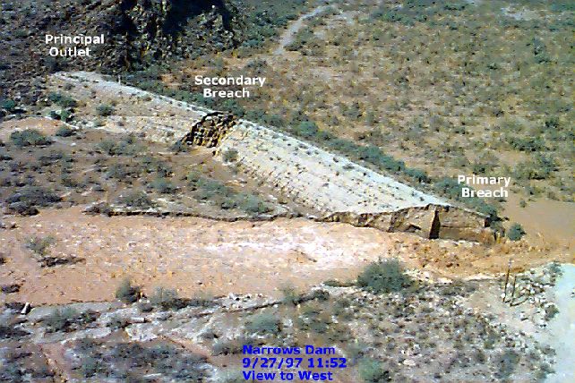
Narrows Dam, Approximately 14 Hours After Failure
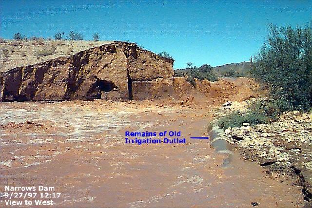
North End of Narrows Dam, 9/27/97 at 12:17 hrs
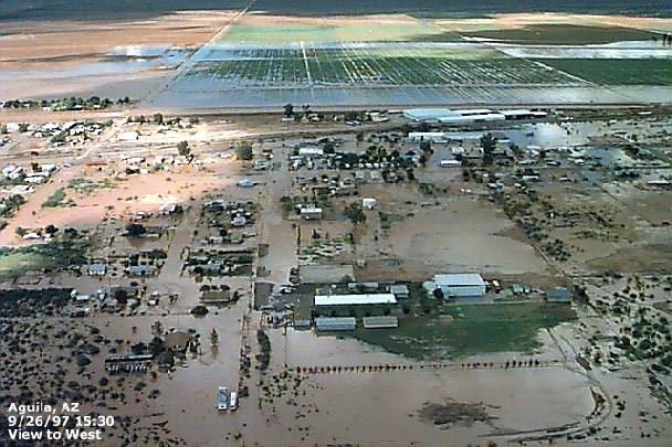
Centennial Wash at Aguila, AZ 9/26/97 at 15:30 hrs
![]()
APPENDIX E - Rainfall Data Recorded at
Harquahala Mountain
Data Display for 5185 Harquahala Mtn. 15-minute Rainfall Totals
Precipitation Gage
StatType rainDataType precip
Date Time inches Raw Units in
09/26/1997-06:19:38 18.46 469 09/26/97
09/26/1997-05:48:29 18.46 469 0700 0.00
09/26/1997-05:08:03 18.43 468 0645 0.00
09/26/1997-04:33:03 18.39 467 0630 0.00
09/26/1997-04:25:43 18.35 466 0615 0.00
09/26/1997-04:23:28 18.31 465 0600 0.04
09/26/1997-04:15:42 18.27 464 0545 0.00
09/26/1997-04:14:29 18.23 463 0530 0.00
09/26/1997-04:11:57 18.19 462 0515 0.04
09/26/1997-04:09:20 18.15 461 0500 0.00
09/26/1997-04:08:14 18.11 460 0445 0.04
09/26/1997-04:07:05 18.07 459 0430 0.12
09/26/1997-04:05:22 18.03 458 0415 0.28
09/26/1997-03:58:41 17.95 456 0400 0.20
09/26/1997-03:52:56 17.91 455 0345 0.12
09/26/1997-03:48:54 17.87 454 0330 0.24
09/26/1997-03:39:22 17.76 451 0315 0.12
09/26/1997-03:37:57 17.72 450 0300 0.16
09/26/1997-03:33:48 17.68 449 0245 0.00
09/26/1997-03:27:45 17.64 448 0230 0.08
09/26/1997-03:24:39 17.60 447 0215 0.04
09/26/1997-03:22:04 17.56 446 0200 0.08
09/26/1997-03:20:14 17.52 445 0145 0.00
09/26/1997-03:15:01 17.44 443 0130 0.16
09/26/1997-03:09:05 17.40 442 0115 0.00
09/26/1997-03:05:10 17.36 441 0100 0.00
09/26/1997-03:01:54 17.32 440 0045 0.08
09/26/1997-02:59:58 17.28 439 0030 0.00
09/26/1997-02:56:52 17.24 438 0015 0.00
09/26/1997-02:46:52 17.20 437
09/25/97
09/26/1997-02:23:54 17.13 435 2400 0.31
09/26/1997-02:11:49 17.05 433 2345 0.20
09/26/1997-01:54:48 17.01 432 2330 0.16
09/26/1997-01:47:26 16.97 431 2315 0.12
09/26/1997-01:15:51 16.93 430 2300 0.24
09/26/1997-00:39:32 16.77 426 2245 0.55
09/26/1997-00:15:22 16.69 424 2230 0.35
09/25/1997-23:58:35 16.69 424 2215 0.16
09/25/1997-23:56:19 16.65 423 2200 0.12
09/25/1997-23:51:13 16.61 422 2145 0.08
09/25/1997-23:49:19 16.57 421 2130 0.16
09/25/1997-23:46:15 16.50 419 2115 0.31
09/25/1997-23:45:30 16.46 418 2100 0.16
09/25/1997-23:43:32 16.38 416 2045 0.20
09/25/1997-23:39:57 16.34 415 2030 0.16
09/25/1997-23:38:19 16.30 414 2015 0.12
09/25/1997-23:36:09 16.26 413 2000 0.28
09/25/1997-23:32:45 16.22 412 1945 0.16
09/25/1997-23:29:47 16.18 411 1930 0.31
09/25/1997-23:27:40 16.14 410 1915 0.12
09/25/1997-23:15:18 16.06 408 1900 0.28
09/25/1997-23:13:34 16.02 407 1845 0.39
09/25/1997-23:05:48 15.98 406 1830 0.39
09/25/1997-23:03:13 15.94 405 1815 0.35
09/25/1997-22:58:00 15.91 404 1800 0.43
09/25/1997-22:55:01 15.87 403 1745 0.20
09/25/1997-22:52:43 15.83 402 1730 0.55
09/25/1997-22:50:24 15.75 400 1715 0.43
09/25/1997-22:49:06 15.71 399 1700 0.20
09/25/1997-22:44:53 15.67 398 1645 0.16
09/25/1997-22:39:56 15.63 397 1630 0.20
09/25/1997-22:39:04 15.59 396 1615 0.20
09/25/1997-22:38:28 15.55 395 1600 0.31
09/25/1997-22:36:52 15.47 393 1545 0.28
09/25/1997-22:34:39 15.39 391 1530 0.39
09/25/1997-22:33:41 15.35 390 1515 0.31
09/25/1997-22:33:06 15.31 389 1500 0.16
09/25/1997-22:31:28 15.24 387 1445 0.04
09/25/1997-22:30:50 15.20 386 1430 0.08
09/25/1997-22:30:04 15.16 385 1415 0.12
09/25/1997-22:26:15 15.12 384 1400 0.12
09/25/1997-22:24:15 15.08 383 1345 0.08
09/25/1997-22:22:28 15.04 382 1330 0.08
09/25/1997-22:19:21 14.96 380 1315 0.04
09/25/1997-22:18:03 14.92 379 1300 0.12
09/25/1997-22:16:45 14.88 378 1245 0.04
09/25/1997-22:15:21 14.84 377 1230 0.00
09/25/1997-22:05:59 14.76 375 1215 0.00
09/25/1997-22:03:54 14.72 374
09/25/1997-22:02:39 14.69 373 TOTAL: 11.97
09/25/1997-22:00:00 14.61 371
09/25/1997-21:56:03 14.57 370
09/25/1997-21:50:08 14.53 369
09/25/1997-21:42:45 14.49 368
09/25/1997-21:23:03 14.41 366
09/25/1997-21:19:57 14.37 365
09/25/1997-21:17:57 14.33 364
09/25/1997-21:16:05 14.29 363
09/25/1997-21:14:32 14.25 362
09/25/1997-21:12:02 14.21 361
09/25/1997-21:09:31 14.17 360
09/25/1997-21:08:22 14.13 359
09/25/1997-21:06:50 14.09 358
09/25/1997-21:04:58 14.06 357
09/25/1997-20:53:43 13.94 354
09/25/1997-20:51:31 13.90 353
09/25/1997-20:49:29 13.86 352
09/25/1997-20:46:05 13.82 351
09/25/1997-20:41:42 13.78 350
09/25/1997-20:38:22 13.74 349
09/25/1997-20:35:11 13.70 348
09/25/1997-20:33:31 13.66 347
09/25/1997-20:30:59 13.62 346
09/25/1997-20:28:22 13.58 345
09/25/1997-20:25:30 13.54 344
09/25/1997-20:05:50 13.43 341
09/25/1997-20:03:43 13.39 340
09/25/1997-20:01:20 13.35 339
09/25/1997-19:59:18 13.31 338
09/25/1997-19:58:01 13.27 337
09/25/1997-19:56:02 13.23 336
09/25/1997-19:53:43 13.19 335
09/25/1997-19:51:15 13.15 334
09/25/1997-19:49:45 13.11 333
09/25/1997-19:46:04 13.07 332
09/25/1997-19:42:11 13.03 331
09/25/1997-19:38:18 12.99 330
09/25/1997-19:34:47 12.95 329
09/25/1997-19:30:17 12.91 328
09/25/1997-19:27:27 12.87 327
09/25/1997-19:23:12 12.80 325
09/25/1997-19:20:27 12.76 324
09/25/1997-19:15:32 12.68 322
09/25/1997-19:06:04 12.56 319
09/25/1997-19:03:20 12.52 318
09/25/1997-19:00:43 12.48 317
09/25/1997-18:58:23 12.44 316
09/25/1997-18:56:34 12.40 315
09/25/1997-18:54:31 12.36 314
09/25/1997-18:50:47 12.28 312
09/25/1997-18:48:42 12.24 311
09/25/1997-18:46:49 12.20 310
09/25/1997-18:44:29 12.17 309
09/25/1997-18:41:13 12.09 307
09/25/1997-18:39:58 12.05 306
09/25/1997-18:38:44 12.01 305
09/25/1997-18:37:43 11.97 304
09/25/1997-18:36:35 11.93 303
09/25/1997-18:34:58 11.89 302
09/25/1997-18:33:08 11.85 301
09/25/1997-18:31:43 11.81 300
09/25/1997-18:29:53 11.77 299
09/25/1997-18:28:29 11.73 298
09/25/1997-18:25:07 11.65 296
09/25/1997-18:23:15 11.61 295
09/25/1997-18:21:37 11.57 294
09/25/1997-18:18:56 11.50 292
09/25/1997-18:17:18 11.46 291
09/25/1997-18:16:11 11.42 290
09/25/1997-18:14:48 11.38 289
09/25/1997-18:13:40 11.34 288
09/25/1997-18:12:29 11.30 287
09/25/1997-18:11:16 11.26 286
09/25/1997-18:09:47 11.22 285
09/25/1997-18:08:10 11.18 284
09/25/1997-18:06:07 11.14 283
09/25/1997-18:02:43 11.10 282
09/25/1997-17:59:27 11.02 280
09/25/1997-17:57:31 10.98 279
09/25/1997-17:56:18 10.94 278
09/25/1997-17:53:21 10.87 276
09/25/1997-17:50:51 10.79 274
09/25/1997-17:49:39 10.75 273
09/25/1997-17:48:29 10.71 272
09/25/1997-17:46:43 10.67 271
09/25/1997-17:40:21 10.59 269
09/25/1997-17:35:42 10.55 268
09/25/1997-17:33:52 10.51 267
09/25/1997-17:31:52 10.47 266
09/25/1997-17:30:42 10.43 265
09/25/1997-17:29:35 10.39 264
09/25/1997-17:28:17 10.35 263
09/25/1997-17:26:38 10.31 262
09/25/1997-17:24:17 10.28 261
09/25/1997-17:22:35 10.24 260
09/25/1997-17:21:22 10.20 259
09/25/1997-17:20:41 10.16 258
09/25/1997-17:20:03 10.12 257
09/25/1997-17:19:05 10.08 256
09/25/1997-17:18:22 10.04 255
09/25/1997-17:17:23 10.00 254
09/25/1997-17:16:37 9.96 253
09/25/1997-17:15:57 9.92 252
09/25/1997-17:15:08 9.88 251
09/25/1997-17:14:24 9.84 250
09/25/1997-17:12:34 9.76 248
09/25/1997-17:11:08 9.72 247
09/25/1997-17:09:48 9.69 246
09/25/1997-17:06:59 9.61 244
09/25/1997-17:05:52 9.57 243
09/25/1997-17:04:32 9.53 242
09/25/1997-17:03:20 9.49 241
09/25/1997-17:01:39 9.45 240
09/25/1997-16:58:01 9.41 239
09/25/1997-16:54:53 9.37 238
09/25/1997-16:52:47 9.33 237
09/25/1997-16:50:13 9.29 236
09/25/1997-16:47:35 9.25 235
09/25/1997-16:43:04 9.21 234
09/25/1997-16:41:01 9.17 233
09/25/1997-16:38:04 9.13 232
09/25/1997-16:29:42 9.06 230
09/25/1997-16:25:03 8.98 228
09/25/1997-16:21:53 8.94 227
09/25/1997-16:15:04 8.90 226
09/25/1997-16:11:25 8.86 225
09/25/1997-16:06:30 8.82 224
09/25/1997-16:02:40 8.78 223
09/25/1997-16:01:59 8.74 222
09/25/1997-16:00:52 8.70 221
09/25/1997-15:59:36 8.66 220
09/25/1997-15:58:26 8.62 219
09/25/1997-15:57:34 8.58 218
09/25/1997-15:56:27 8.54 217
09/25/1997-15:54:10 8.50 216
09/25/1997-15:50:17 8.46 215
09/25/1997-15:48:32 8.43 214
09/25/1997-15:46:29 8.39 213
09/25/1997-15:43:25 8.35 212
09/25/1997-15:41:17 8.31 211
09/25/1997-15:38:08 8.27 210
09/25/1997-15:35:46 8.23 209
09/25/1997-15:34:11 8.19 208
09/25/1997-15:32:51 8.15 207
09/25/1997-15:30:00 8.07 205
09/25/1997-15:28:55 8.03 204
09/25/1997-15:27:34 7.99 203
09/25/1997-15:26:09 7.95 202
09/25/1997-15:24:24 7.91 201
09/25/1997-15:22:50 7.87 200
09/25/1997-15:20:49 7.83 199
09/25/1997-15:19:17 7.80 198
09/25/1997-15:17:16 7.76 197
09/25/1997-15:12:02 7.68 195
09/25/1997-15:10:34 7.64 194
09/25/1997-15:08:31 7.60 193
09/25/1997-15:05:04 7.56 192
09/25/1997-15:03:40 7.52 191
09/25/1997-15:02:11 7.48 190
09/25/1997-14:55:21 7.36 187
09/25/1997-14:51:52 7.32 186
09/25/1997-14:47:17 7.28 185
09/25/1997-14:32:18 7.20 183
09/25/1997-14:22:08 7.17 182
09/25/1997-14:17:58 7.13 181
09/25/1997-14:12:15 7.09 180
09/25/1997-14:03:07 7.01 178
09/25/1997-13:57:19 6.97 177
09/25/1997-13:53:14 6.93 176
09/25/1997-13:48:34 6.89 175
09/25/1997-13:42:20 6.85 174
09/25/1997-13:31:51 6.81 173
09/25/1997-13:24:06 6.77 172
09/25/1997-13:16:30 6.73 171
09/25/1997-13:08:46 6.69 170
09/25/1997-12:58:05 6.65 169
09/25/1997-12:53:48 6.61 168
09/25/1997-12:45:33 6.57 167
09/25/1997-12:31:59 6.54 166
09/25/1997-12:06:57 6.50 165 Rainfall Begins
End of Report.