Links
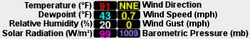
Weather
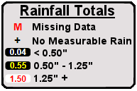
Rainfall
M = Gage has not reported in last 6 hours. Data missing.
MCDAQ Current Data

All QPF rainfall values are FORECAST ESTIMATES in the event that storms develop.

This site provides current rainfall, weather, stream and impoundment information for Maricopa County and nearby counties. These data are updated every 5 minutes.
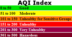
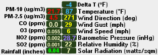
Use the Datasets Menu and Dailog to change rainfall period or select weather, temperature, streamflow, impoundment, or Air Quality Data. Use the Layers menu to turn on/off NWS Warnings, Radar, and Satellite imagery.
NWS Warning Areas provided by NWS RIDGE Displays (http://radar.weather.gov/ridge)
Radar, precipitation estimates, and satellite imagery layers provided by Weather Decision Technologies (WDT): http://www.wdtinc.com
Ridge 2 Radar is provided by National Weather Service (NWS).
This map was created from provisional data that has not been checked or verified for accuracy. Some data on this map comes from sources other than Flood Control District of Maricopa County. Flood Control District of Maricopa County has no control over the accuracy and type of data transmitted. This map was created solely for the convenience of the County and related public agencies. The County does not warrant the accuracy of this map, and no decision involving a risk of economic loss or physical injury should be made from the data available on this site.
This layer displays the current Quantitative Precipitation Forecast
from the Flood Control District of Maricopa County ALERT System.
All QPF rainfall values are FORECAST ESTIMATES in the event that storms develop.
They are not to be confused with observational rainfal values.
Link to text product http://alert.fcd.maricopa.gov/alert/Wx/MSP_Parcel_QPF.txt.
Please direct all questions or comments concerning the data above to: Daniel Henz at [email protected].

Map Produced by FCDMC Flood Warning Branch
Email Chandra Miller at [email protected].
The Flood Control District of Maricopa County
2801 W. Durango Street
Phoenix, AZ 85009
Phone: (602) 506-1501
Fax: (602) 506-4601
http://www.fcd.maricopa.gov/
Rainfall and Weather Webpage
Flood Control District of Maricopa County Website