Links
Rainfall
M = Gage has not reported in last 6 hours. Data missing.
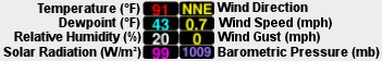
MCDAQ Current Data
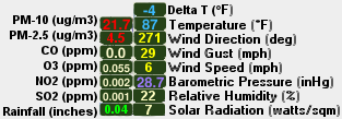
Warning: These data have been obtained from automated instruments and have not been subjected to a quality assurance review to determine their accuracy. They are presented for public awareness and should not be considered final. Conditions such as power outages and equipment malfunctions can produce invalid data. Please note that not every pollutant is measured at every site.
These data are updated every 15 minutes. The map refreshes current dataset every 2 minutes.
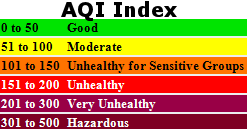
Use the Datasets Menu and Dialog to change select a AQI value. Use the Current Data Menu and Dialog to view the MCAQD Current Weather Data, individual sensor data, FCDMC weather data and FCDMC 24 hour rainfall totals. Use the Layers menu to turn on/off NWS Warnings, Radar, and Satellite imagery.
Peak Wind, NO2, O2, CO, PM-2.5, West Phoenix PM-10, and North Phoenix PM-10 are updated hourly and everything else is updated every five minutes.
NWS Warning Areas provided by NWS RIDGE Displays (http://radar.weather.gov/ridge)
Radar, precipitation estimates, and satellite imagery layers provided by Weather Decision Technologies (WDT): http://www.wdtinc.com
![]()

Map Produced by FCDMC Flood Warning Branch
Email Ceresa Stewart at [email protected] or Ben Davis at [email protected]
Maricopa County Department of Air Quality
2145 S. 11th Ave #170
Phoenix, AZ 85007
Air Monitoring
Flood Control District of Maricopa County Website