Flood Control District of Maricopa County
Storm Report - July 14-15, 1999
![]()
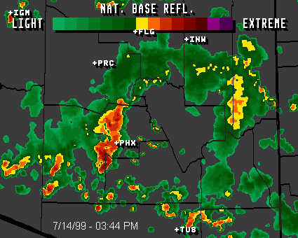
METEOROLOGY
The airmass over Maricopa County on July 14th was unusually moist, with water content above normal for July. This condition was also present the previous 4 or 5 days, but no significant rains took place, though there was rain on the 13th over portions of the County. However, on these previous days there were significant and rather widespread storms over far western Arizona and southeast California due to a stationary disturbance in the upper atmosphere over this area.
A small portion of this disturbance moved across Maricopa County on the 13th, but the main portion remained centered near the Colorado River. The bulk of the upper air disturbance moved into Maricopa County on the 14th. This unseasonably strong disturbance (making the air unstable), coupled with a very moist airmass resulted in our significant rains.
Note: This was a very unusual event. One reason is it occurred during the morning and afternoon hours. Normally we see our action during the evening. For another, the thunderstorms moved in from the southwest, rather than the southeast to northeast. Southwest winds usually result in NO thunderstorms, as higher terrain (such as to our east) is necessary to form the storms.
EJP
![]()
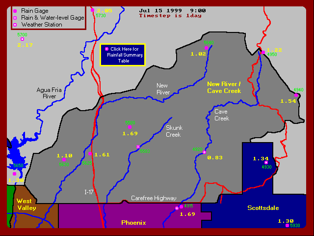
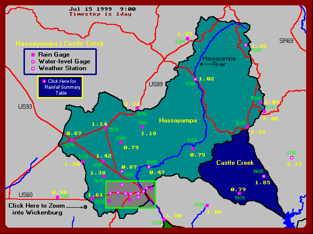
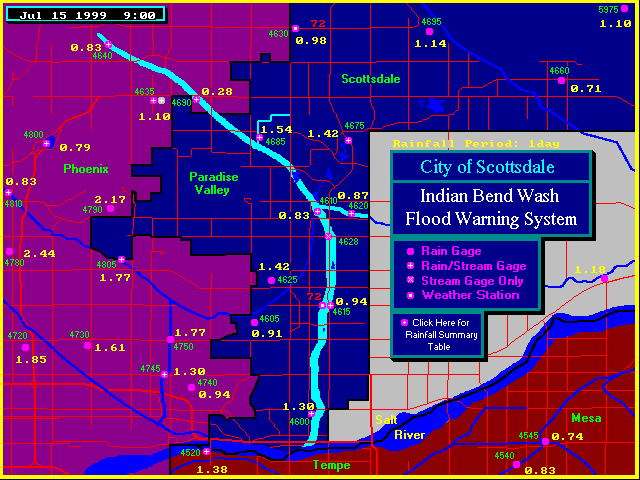
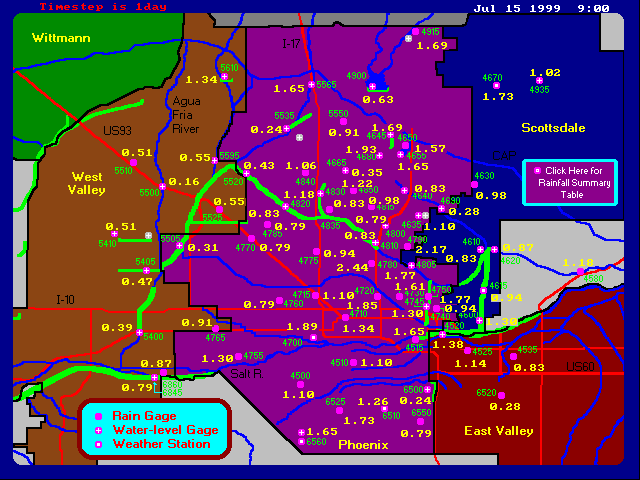
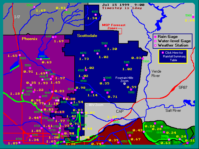
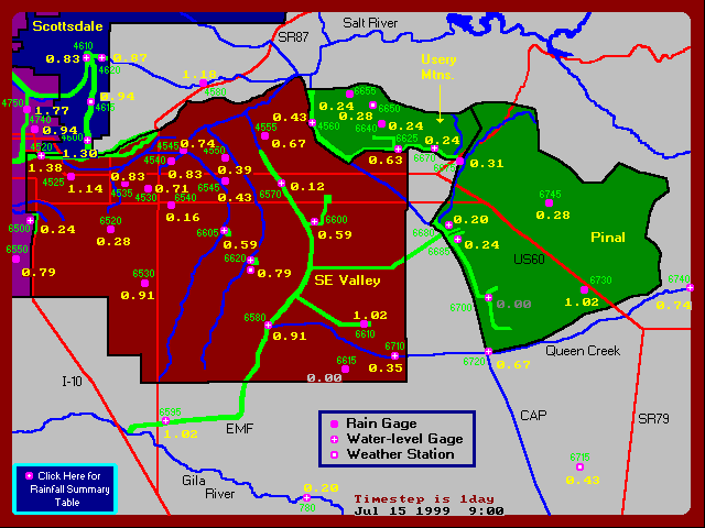
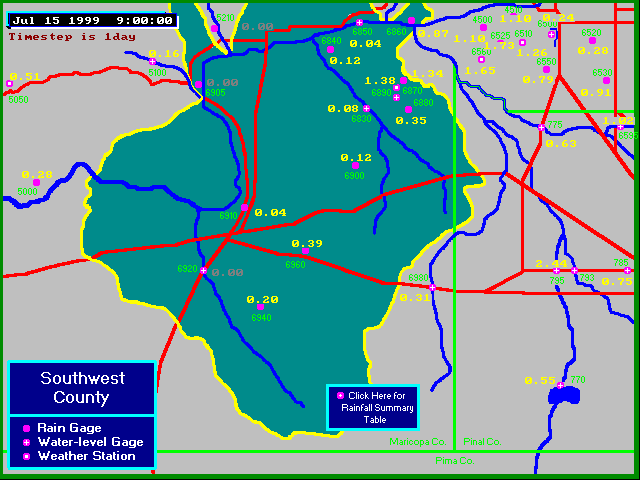
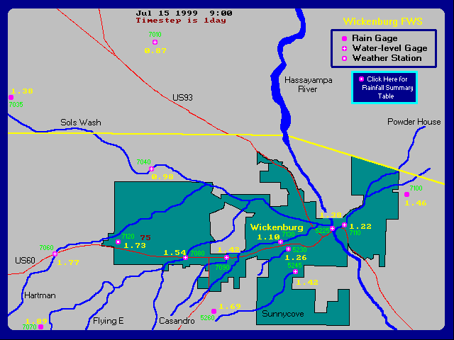
PRECIPITATION
Summary Statistics:
Total Automated Rain Gages: 227
Total Operational Automated Rain Gages: 225
Queen Creek Landfill had a locked tipping bucket, all remaining gages functioned throughout the event. South Mtn. Park HQ had a programming error which caused it to count by 2 instead of 1 during parts of the event - this data was edited and considered correct for this report.
For the period 7/14/99 09:00 through 7/15/99 09:00 -
|
Number of gages reporting more than 2.5 inches: |
2 |
|
Number of gages reporting more than 2.0 inches: |
12 |
|
Number of gages reporting more than 1.5 inches: |
42 |
|
Number of gages reporting more than 1.0 inch: |
100 |
|
Number of gages reporting more than 0.50 inch: |
167 |
|
Number of gages reporting more than 0.01 inch: |
218 |
|
Number of gages reporting no rainfall: |
7 |
Depth-Duration Table For Selected Automated Rain Stations
|
Duration |
10-Year Phoenix |
10-Year Carefree |
Missouri @16th St. |
Paradise Valley CC |
Pima @ Jomax |
Flying E Tank |
Durango Complex |
|
5-min. |
.47 |
.44 |
.35 |
.43 |
.20 |
.20 |
.34 |
|
10-min. |
.72 |
.68 |
.63 |
.71 |
.35 |
.39 |
.62 |
|
15-min. |
.92 |
.86 |
.71 |
.87 |
.43 |
.47 |
.89 |
|
30-min. |
1.27 |
1.19 |
.87 |
.98 |
.67 |
.71 |
1.33 |
|
1-hour |
1.61 |
1.51 |
1.54 |
1.65 |
.91 |
.87 |
1.60 |
|
3-hour |
1.82 |
1.87 |
1.65 |
1.65 |
1.02 |
1.50 |
1.64 |
|
6-hour |
2.07 |
2.32 |
1.85 |
1.69 |
1.02 |
1.50 |
1.64 |
|
12-hour |
2.30 |
2.72 |
1.85 |
1.69 |
1.06 |
1.69 |
1.65 |
|
18-hour |
|
|
2.24 |
2.17 |
1.73 |
1.89 |
1.88 |
|
24-hour |
2.53 |
3.13 |
2.44 |
2.17 |
1.73 |
1.93 |
1.89 |
Appendix A contains a listing of rainfall depths measured at all stations for the 24-hour period ending on 07/15/99 at 09:00, in order of descending depth. Appendix B - download hourly values for all rain stations.
![]()
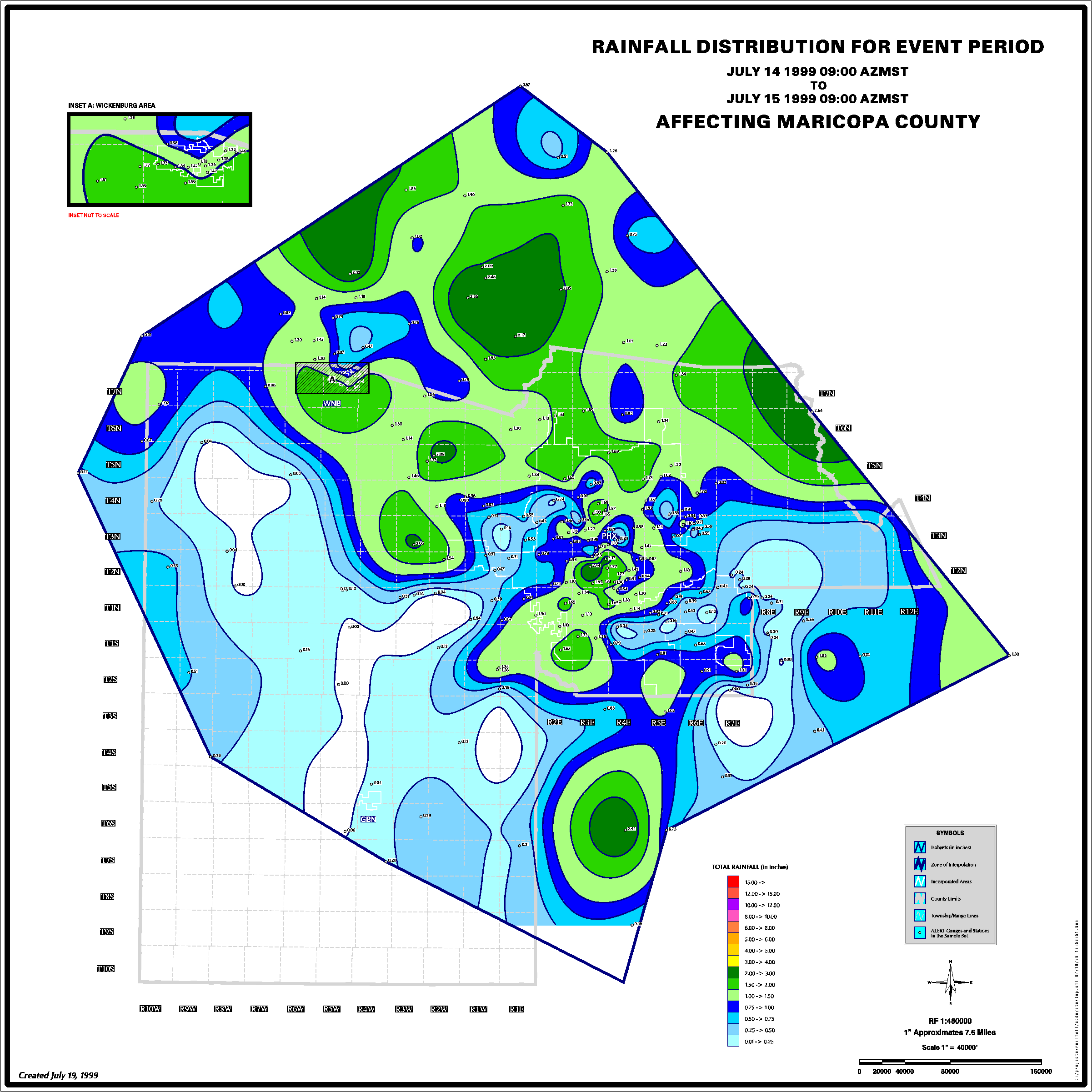
Rainfall Maps - 24 Hours Ending 07/15/99 @ 09:00
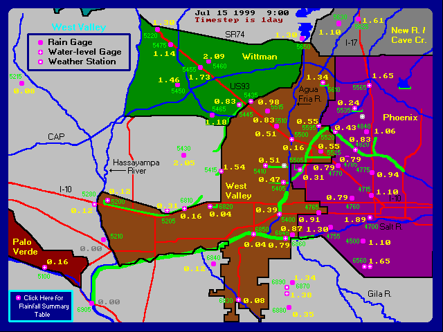
View an Isohyetal Map for this Storm (212 KB)
![]()
RUNOFF
Summary Statistics:
Total Automated Water-level Gages Installed: 103
Total Operational Automated Rain Gages: 101 - Indian Bend Wash @ Indian Bend Rd. and Indian Bend Wash Interceptor were out of service due to construction projects.
Water-level Gages which failed to operate during the Storm: 2 - ACDC @ 14th Street and Rittenhouse FRS
Number of Impoundment Structures measuring flow: 16 - (see Impoundment Stations Table)
Number of Stream Stations measuring flow: 43 - (see Stream Stations Table)
Impoundment Stations Table
|
Peak Stage |
Peak Outflow |
Peak Storage |
Peak Capacity |
Date-Time |
||
|
Structure Name |
ID |
(ft) |
(cfs) |
(ac-ft) |
(% full) |
|
|
10th St. Wash Basin #1 |
4818 |
1.23 |
7 |
0.5 |
2 |
7/14-16:38 |
|
Adobe Dam |
5539 |
6.74 |
311 |
134 |
1 |
7/15-12:59 |
|
Aspen Dam |
5988 |
0.70 |
10 |
-- |
-- |
7/14-17:20 |
|
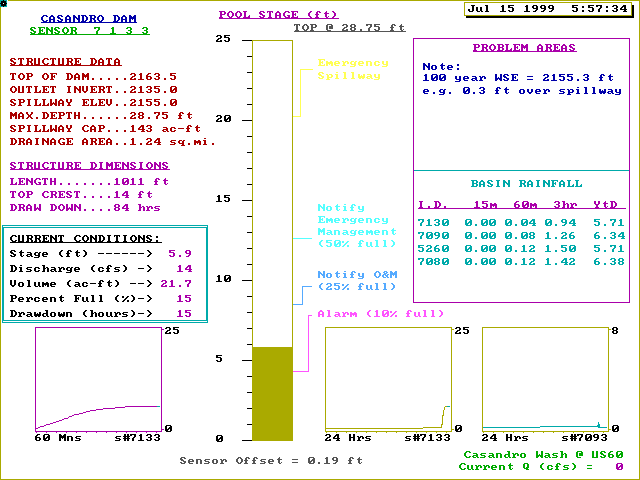
Casandro Dam |
7133 |
5.86 |
14 |
21.7 |
15 |
7/15-05:57 |
|
Cave Buttes Dam |
4904 |
17.9 |
203 |
516 |
1 |
7/15-19:37 |
|
Dreamy Draw Dam |
4803 |
0.68 |
4 |
-- |
-- |
7/14-16:53 |
|
E.Fork CC #1 |
4648 |
1.25 |
15 |
1.2 |
2 |
7/14-16:22 |
|
E.Fork CC #3 |
4683 |
3.60 |
312 |
32.1 |
18 |
7/14-17:12 |
|
E.Fork CC #4 |
4658 |
3.65 |
71 |
8.4 |
11 |
7/14-16:24 |
|
Golden Eagle Park Dam |
5978 |
3.36 |
91 |
-- |
-- |
7/14-12:21 |
|
Hesperus Dam |
5993 |
1.05 |
12 |
-- |
-- |
7/14-16:29 |
|
New River Dam |
5614 |
5.52 |
353 |
236 |
1 |
7/15-12:34 |
|
North Heights Dam |
5983 |
0.97 |
12 |
-- |
-- |
7/14-18:13 |
|
Stone Ridge Dam |
5968 |
0.91 |
4 |
-- |
-- |
7/15-09:19 |
|
Sunnycove FRS |
5248 |
10.07 |
33 |
8.4 |
4 |
7/15-06:19 |
|
Sunset FRS |
5233 |
6.80 |
22 |
9.6 |
11 |
7/15-05:40 |
Stream Stations Table
|
Peak Discharge |
Peak Stage |
Date-Time |
||
|
Water-level Sensor Name |
ID |
(cfs) |
(ft) |
|
|
ACDC @ 36th St. |
4808 |
324 |
7.67 |
7/14-17:28 |
|
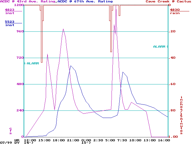
ACDC @ 43rd Ave. |
4823 |
1195 |
1.73 |
7/15-07:08 |
|
ACDC @ 67th Ave. |
5523 |
650 |
4.00 |
7/14-21:40 |
|
Adobe Dam Outlet |
5538 |
508 |
4.50 |
7/15-12:44 |
|
Agua Fria @ Buckeye |
5403 |
328 |
0.70 |
7/15-12:10 |
|
Agua Fria @ Grand |
5503 |
326 |
3.56 |
7/15-15:49 |
|
Berneil Wash |
4688 |
447 |
1.73 |
7/14-16:57 |
|
Casandro Wash |
7093 |
42 |
0.55 |
7/15-04:53 |
|
Cave Buttes Outlet * |
4903 |
32 |
1.94 |
7/14-15:48 |
|
Cave Cr. @ Spur Cross |
4923 |
1500 |
7.51 |
7/15-08:51 |
|
Cave Cr. Nr Cave Creek |
4918 |
393 |
1.65 |
7/15-08:26 |
|
Cave Creek @ Cactus |
4833 |
1154 |
11.28 |
7/14-19:15 |
|
Centennial Wash @ Wenden |
5093 |
209 |
1.00 |
7/14-19:28 |
|
Colter Channel @ El Mirage |
5408 |
37 |
0.75 |
7/15-07:34 |
|
Dysart Channel @ El Mirage |
5423 |
39 |
0.95 |
7/15-07:19 |
|
Dysart Drain @ LAFB |
5413 |
73 |
1.18 |
7/15-10:33 |
|
EFCC nr 7th Ave. |
4668 |
847 |
4.45 |
7/14-17:04 |
|
Estrella Fan |
6893 |
3 |
0.10 |
7/14-15:52 |
|
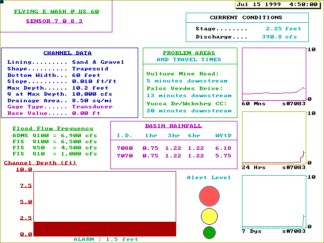
Flying E Wash |
7083 |
444 |
2.38 |
7/15-04:49 |
|
Gila @ Olberg |
0783 |
462 |
1.04 |
7/15-08:11 |
|
Guadalupe Channel |
6603 |
115 |
0.85 |
7/15-08:34 |
|
Hartman Wash |
7063 |
97 |
0.95 |
7/15-04:54 |
|
Hassy @ Box Canyon |
5308 |
560 |
4.20 |
7/15-10:30 |
|
Hassy @ Wagoner Rd. |
5353 |
300 |
4.15 |
7/15:05:02 |
|
IBW @ Indian School |
4618 |
624 |
3.23 |
7/14-21:59 |
|
IBW @ McDonald |
4628 |
677 |
1.20 |
7/14-20:56 |
|
IBW @ McKellips |
4603 |
320 |
1.67 |
7/15-09:37 |
|
IBW @ Shea Blvd. |
4693 |
896 |
2.20 |
7/14-17:15 |
|
IBW @ Sweetwater |
4643 |
159 |
1.35 |
7/14-16:26 |
|
Lake Marguarite |
4678 |
237 |
1.75 |
7/14-17:00 |
|
McMicken Floodway |
5438 |
98 |
1.65 |
7/15-08:01 |
|
New River @ Bell |
5598 |
155 |
0.60 |
7/15-22:48 |
|
New River @ Glendale |
5508 |
1525 |
1.55 |
7/15-09:30 |
|
New River Dam Outlet |
5613 |
198 |
4.59 |
7/15-10:52 |
|
Old X-cut @ McDowell |
4748 |
239 |
1.40 |
7/14-16:40 |
|
Powder House Wash |
7113 |
23 |
0.30 |
7/15-05:14 |
|
Sauceda Wash |
6923 |
284 |
2.21 |
7/14-23:33 |
|
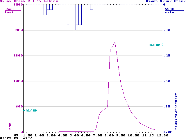
Skunk Cr. @ I-17 |
5568 |
2119 |
3.27 |
7/15-08:52 |
|
Skunk Cr. Nr New River |
5583 |
950 |
3.95 |
7/15-05:41 |
|
Sols Wash nr Matthie |
7043 |
468 |
0.65 |
7/15-06:08 |
|
South Mountain Fan |
6563 |
245 |
1.65 |
7/14-16:22 |
|
Tatum Basin Inflow |
4638 |
41 |
0.38 |
7/14-17:32 |
|
Vekol Wash |
6983 |
700 |
3.85 |
7/14-19:09 |
![]()
Selected Runoff Plots
![]()
APPENDIX A
FLOOD CONTROL DISTRICT OF MARICOPA COUNTY
Precipitation Report - 24 hours ending 7/15/99 at 09:00
*** Data is Preliminary ***
|
Gage Name |
Storm Total |
Month Total |
Year Total |
Gage Location |
|
Mt. Ord |
2.64 |
3.03 |
5.87 |
Top of Mt. Ord, 4 mi. E of Sunflower in the Mazatzal Mtns. |
|
Minnehaha |
2.56 |
5.08 |
8.15 |
8 mi. E of Wagoner, Yavapai County |
|
Crown King |
2.48 |
6.18 |
9.76 |
Crown King, Bradshaw Mtns, 24 mi. SSE of Prescott |
|
Santa Rosa @ SR 84 |
2.44 |
3.78 |
4.80 |
11 mi. West of SR 93 (Casa Grande) on SR 84 |
|
Missouri @ 16th St. |
2.44 |
3.03 |
4.49 |
1/2 mi. North of Camelback Rd. and 16th St. |
|
Yarnell Hill |
2.32 |
3.78 |
6.97 |
1 mi. ENE of Yarnell, Yavapai County |
|
Horsethief Basin |
2.17 |
3.90 |
8.54 |
At HB Recreation Area, 6 mi. SE of Crown King |
|
P.V. Country Club |
2.17 |
2.72 |
4.06 |
1/2 mi. North of Lincoln Dr. and Tatum Blvd. |
|
Towers Mtn. |
2.09 |
3.66 |
8.46 |
3 mi. NW of Crown King, Yavapai County |
|
Chrysler P. Ground |
2.09 |
2.36 |
4.13 |
3 mi. ESE of Circle City, 1.5 mi. N of Wittmann |
|
Sunset Point |
2.05 |
3.86 |
7.95 |
Rest Area on I-17, 10 mi. N of Black Canyon City |
|
White Tanks E.P. |
2.05 |
3.15 |
4.92 |
Top of White Tank Mtns., 13 mi. N of Buckeye |
|
E.Fork CC #3 |
1.93 |
2.24 |
3.94 |
1/2 mi. SW of Union Hills Dr. and Cave Creek Rd. |
|
Flying E Tank |
1.89 |
2.28 |
4.80 |
6.3 mi. WSW of the US 93 / US 89 junction at Wickenburg |
|
Wilhoit |
1.85 |
2.83 |
5.59 |
At Wilhoit, 10 mi. SSW of Prescott, Yavapai County |
|
Columbia Hill |
1.85 |
2.80 |
6.50 |
5 mi. NNW of Castle Hot Springs |
|
Thomas & 16th St. |
1.85 |
2.20 |
3.54 |
16 th St. at Thomas Rd. |
|
Hartman Wash |
1.77 |
2.48 |
5.16 |
On US 60 bridge, 6.3 mi. West of US 60 / US 93 |
|
Thomas @ 48th St. |
1.77 |
2.17 |
3.23 |
Thomas Rd. and 48th St. |
|
ACDC @ 36th St. |
1.77 |
2.09 |
3.35 |
1/2 mi. North of 36th St. and Camelback Rd. |
|
Pima @ Jomax |
1.73 |
2.87 |
5.63 |
1/8 mi. NW of Pima Rd. and Jomax Rd. |
|
South Mtn.Park HQ |
1.73 |
4.45 |
6.27 |
In South Mtn. Park, alignments of Elliot and 7th Ave. |
|
Arizona Hunt Club |
1.73 |
2.56 |
5.59 |
5 mi. NNW of Cordes Junction |
|
Wickenburg Airport |
1.73 |
2.24 |
4.88 |
4.5 mi. West of the US 60 / US 93 junction |
|
Wittmann |
1.73 |
2.13 |
4.06 |
US 60/93 at Wittmann, 4 mi. SE of Circle City |
|
Upper Skunk Creek |
1.69 |
2.87 |
5.39 |
4 mi. E of New River |
|
Vulture Mine |
1.69 |
2.56 |
5.12 |
3 mi. SW of Wickenburg |
|
Cave Creek Landfill |
1.69 |
2.48 |
4.72 |
1/2 mi. E of Carefree Hwy. and the 40th St. alignment |
|
E.Fork CC #1 |
1.69 |
2.13 |
3.82 |
1/4 mi. E of Beardsley Rd. and Cave Creek Rd. |
|
South Mountain Fan |
1.65 |
3.82 |
5.75 |
Alignments of Ray Rd. and 35th Ave. in S. Mtn. Park |
|
Skunk Creek @ I-17 |
1.65 |
3.50 |
5.51 |
I-17 at Jomax Rd. alignment |
|
Durango Complex |
1.65 |
2.24 |
3.74 |
27th Ave. and Durango St. |
|
E.Fork CC #4 |
1.65 |
1.97 |
4.25 |
1/4 mi. S of Union Hills Dr. and 32nd St. |
|
Salt R. @ 40th St. |
1.65 |
1.81 |
2.60 |
S. side of Salt River near 40th St. |
|
Sunup Ranch |
1.61 |
2.32 |
4.53 |
1 mi. SSW of New River |
|
Black Mountain |
1.61 |
1.97 |
4.25 |
Along US 60, 9 mi. West of US 60 / US 93n at Wickenburg |
|
Perry Park |
1.61 |
1.97 |
3.11 |
1/8 mi. S of Thomas Rd. and 32nd St. |
|
ParadiseValley Park |
1.57 |
1.97 |
3.82 |
1/2 mi. E of Union Hills Dr. and 32nd St. |
|
Humboldt Mountain |
1.54 |
2.83 |
4.76 |
13 mi. NE of the Town of Cave Creek |
|
Berneil Wash |
1.54 |
2.72 |
4.37 |
Just east of Doubletree and Invergordon |
|
Flying E Wash |
1.54 |
2.32 |
4.88 |
On US 60 bridge, 3 mi. West of US 60 / US 93 |
|
White Tanks #3 |
1.54 |
1.77 |
3.54 |
4 mi. N of I-10 on Jackrabbit Trail alignment |
|
Mt. Union |
1.46 |
3.58 |
9.92 |
Top of Mt. Union, 10 mi. SSE of Prescott |
|
Constellation Road |
1.46 |
2.28 |
4.72 |
1.4 mi. NE of the US 60 / US 93 junctionon |
|
Patton Rd. |
1.46 |
2.09 |
4.21 |
7 mi. E of Grand Ave. on Patton Rd. |
|
Lake Marguarite |
1.42 |
3.07 |
4.61 |
1/4 mi. W of Doubletree and Hayden Rd. |
|
Flores West |
1.42 |
2.56 |
5.12 |
Along US 93, 3.2 mi. NW of the US 93 / US 89 junction |
|
Casandro Wash |
1.42 |
2.20 |
4.84 |
On US 60 bridge, 2 mi. West of US 60 / US 93 |
|
Sunnycove FRS |
1.42 |
1.97 |
4.33 |
1 mi. SW of the US 60 / US 93 intersection in Wickenburg |
|
Highland @ 68th St. |
1.42 |
1.85 |
3.19 |
1/4 mi. N of Highland and 68th Street |
|
Signal Peak |
1.38 |
4.45 |
5.67 |
8 mi. SSW of Globe |
|
Black Hill |
1.38 |
2.99 |
5.51 |
2.3 miles WSW of the US 93 / US 89 junction |
|
Hassayampa @ US 60 |
1.38 |
2.24 |
4.45 |
Hassayampa River at US 60/93 in Wickenburg |
|
Estrella Fan |
1.38 |
2.24 |
3.50 |
Alignments of El Mirage Rd. and Germann Rd. |
|
Horseshoe Ranch |
1.38 |
1.89 |
4.61 |
10 mi. SE of Cordes Junction |
|
Salt R. @ Priest Dr |
1.38 |
1.65 |
2.76 |
West side of Salt River bridge at Priest Drive |
|
Carefree Ranch |
1.34 |
2.52 |
5.75 |
3.5 mi. NE of Skyranch Airport |
|
New River Dam |
1.34 |
2.40 |
4.69 |
1/2 mi. NE of Jomax Rd. and 83rd Ave. |
|
Jefferson @ 4th Ave |
1.34 |
2.09 |
3.27 |
County Building, 4th Ave. and Jefferson St. |
|
Upper Estrella Fan |
1.34 |
1.97 |
3.19 |
1/2 NE of the El Mirage & Germann Rd Alignments |
|
IBW @ McKellips Rd. |
1.30 |
2.83 |
4.25 |
On Indian Bend Wash 1/4 mi. South of McKellips |
|
Lake Pleasant |
1.30 |
2.72 |
4.69 |
On New Waddell Dam at Lake Pleasant |
|
Morristown |
1.30 |
2.60 |
4.80 |
US 60/93 at Morristown, 10 mi. SE of Wickenburg |
|
Sols Tank |
1.30 |
2.56 |
5.35 |
6.3 mi. WNW of the US 93 / US 89 junction |
|
Salt R. @ 67th Ave |
1.30 |
2.13 |
3.66 |
67th Ave & Roeser St., N of Salt River |
|
Fraesfield Mountain |
1.30 |
1.65 |
5.16 |
Near the alignments of Dixaleta Dr. and 128th St. |
|
Old Xcut @ McDowell |
1.30 |
1.65 |
2.83 |
McDowell Rd. at Hohokam Expressway |
|
I-17 at SR 169 |
1.26 |
2.28 |
4.80 |
I-17 at SR 169 (Cherry Rd.) |
|
Sunset FRS |
1.26 |
1.93 |
4.41 |
3/4 mi. WSW of the US 60 / US 93 intersection in Wickenburg |
|
South Mountain Park |
1.26 |
1.89 |
3.03 |
Alignments of Elliot Rd. and 24th St. |
|
Seven Springs |
1.22 |
2.56 |
5.35 |
15 mi. NNE of the Town of Cave Creek |
|
Powder House Wash |
1.22 |
2.05 |
4.25 |
1/2 mi. NE of the junction of US 60 and Constellation Rd. |
|
T-bird @ 7th St. |
1.22 |
1.77 |
3.11 |
1/4 mi. SW of Thunderbird Rd. and 7th St. |
|
Stanton |
1.18 |
2.52 |
5.31 |
6.5 mi. East of Congress, Yavapai County |
|
Cave Creek @ Cactus |
1.18 |
2.40 |
3.58 |
1/4 mi. ENE of I-17 and Cactus Rd. |
|
NW Regional Landfil |
1.18 |
2.01 |
3.82 |
Near 195th Ave. and Deer Valley Rd. |
|
Salt River Landfill |
1.18 |
1.18 |
2.40 |
1/4 mi. N of Gilbert Rd. at Beeline Highway |
|
Circle City |
1.14 |
2.01 |
4.37 |
Along US 60/93, 14 mi. SE of Wickenburg |
|
Aztec Park |
1.14 |
1.85 |
3.43 |
Near Thunderbird at Frank Lloyd Wright Blvd. |
|
ASU South |
1.14 |
1.69 |
2.99 |
1/4 mi. NNE of Broadway Rd. and Mill Ave. |
|
Congress |
1.14 |
1.46 |
3.78 |
Junction of US 89 and SR 71 |
|
New River Landfill |
1.10 |
2.01 |
3.94 |
4 mi. ENE of New Waddell Dam |
|
Cesar Chavez Park |
1.10 |
2.01 |
3.39 |
South end of park, 35th Ave. and Baseline Rd. |
|
Casandro Dam |
1.10 |
1.89 |
4.25 |
1.1 mi. West of the US 60 / US 93 junction |
|
Grand @ 27th Ave. |
1.10 |
1.57 |
2.80 |
Grand Avenue near 27th Avenue |
|
Tatum Basin Rain |
1.10 |
1.50 |
3.27 |
Near Shea Blvd. and 44th St. |
|
Roeser @ 2nd St. |
1.10 |
1.50 |
1.54 |
1/2 mi. SSE of Broadway Rd. and Central Ave. |
|
Cloudburst Wash |
1.10 |
1.10 |
3.58 |
2mi. NW of SunRidge Golf Course, Fountain Hills |
|
Greenway & 32nd Ave |
1.06 |
2.13 |
3.58 |
1/4 mi. East of Greenway Rd. and 32nd Ave. |
|
Castle Hot Springs |
1.06 |
1.42 |
3.54 |
6 mi. NE from US 60/93 on Castle Hot Springs Rd. |
|
Pinnacle Peak Vista |
1.02 |
2.48 |
4.41 |
1/2 mi. SSE of Deer Valley Rd. & Pima Rd. |
|
Pima @ Union Hills |
1.02 |
2.48 |
4.25 |
1/4 mi. W of Pima Rd. and Union Hills |
|
Cooks Mesa |
1.02 |
2.40 |
5.71 |
10 mi. E of Black Canyon City in the New River Mtns. |
|
Hassy @ Wagoner Rd |
1.02 |
2.20 |
5.47 |
6 mi. ESE of Kirkland Junction |
|
Gladden |
1.02 |
2.09 |
3.98 |
US 60 at Gladden, 34 miles W of Wickenburg |
|
McDowell Mtn. Park |
1.02 |
1.85 |
4.84 |
Off Palisades Dr., McDowell Mtn. Park, 4 mi. WSW of Rio Verde |
|
Florence Junction |
1.02 |
1.57 |
3.66 |
1.5 mi. NW of Florence Junction |
|
Queen Creek Rd. |
1.02 |
1.34 |
2.99 |
1/4 mi. NE of Queen Creek Rd. and Ellsworth Rd. |
|
EMF @ Arizona Ave. |
1.02 |
1.30 |
2.99 |
On the SR 587 bridge 3 mi. South of Riggs Rd. |
|
Reata Pass Dam |
1.02 |
1.18 |
4.13 |
1/2 mi. South of Dynamite Blvd. and 112th St. |
|
10 St.Wash Basin #1 |
0.98 |
2.01 |
3.19 |
1/4 mi. SW of Peoria Ave. and Cave Creek Rd. |
|
McMicken Floodway |
0.98 |
1.77 |
3.46 |
1/2 mi. N of Grand Ave. and Deer Valley Rd. |
|
Thunderbird Academy |
0.98 |
1.73 |
3.35 |
1/4 mi. ESE of Thunderbird Rd. and Scottsdale Rd. |
|
Sols Wsh nr Matthie |
0.98 |
1.57 |
3.74 |
Sols Wash at SPRR bridge, 2 mi. N. of Wickenburg Airport |
|
Centennial Wash |
0.98 |
1.34 |
3.39 |
1 mi. N of US 60, 19 mi. W of Wickenburg |
|
Golden Eagle Blvd. |
0.94 |
1.97 |
5.08 |
NW1/4 of T3N-R6E-Section 5 at Chaparral Water Tank |
|
Papago Park |
0.94 |
1.65 |
2.76 |
1/4 mi. N of McDowell Rd. and 52nd St. |
|
IBW @ Indian School |
0.94 |
1.46 |
2.76 |
Indian School Road at Hayden Road |
|
Maryland @ 27th Ave |
0.94 |
1.14 |
2.60 |
Near I-17, 1/2 mi. North of Bethany Home Rd. |
|
Smith Peak |
0.91 |
2.56 |
4.09 |
Harcuvar Mtns., 13 mi. NW of Aguila |
|
Deer Valley Airport |
0.91 |
2.05 |
4.06 |
Deer Valley Rd. and 7th Ave. |
|
Osborn @ 64th St. |
0.91 |
1.65 |
2.87 |
200 yds. E. of Osborn Rd. and 64th Street |
|
Hesperus Wash |
0.91 |
1.54 |
4.65 |
NW1/4 of T4N-R6E-Section 31 near Dixie Mine |
|
Buckeye @ 75th Ave. |
0.91 |
1.34 |
2.95 |
1/4 mi. N of Buckeye Rd. and 75th Ave. |
|
Chandler @ AlmaSchl |
0.91 |
1.26 |
2.80 |
1/4 mi. SE of Chandler Blvd. and Alma School Rd. |
|
EMF @ Queen Creek |
0.91 |
1.18 |
2.32 |
1/3 mi. West of Queen Creek Rd. and Higley Rd. |
|
IBW Interceptor |
0.87 |
2.87 |
4.17 |
1/4 mi. SW of Pima Rd. & Indian Bend Rd. |
|
Prescott Valley |
0.87 |
2.32 |
5.24 |
5 mi. N of the intersection of SR 69 and Roberts Rd. |
|
Martinez Creek |
0.87 |
2.20 |
4.53 |
1 mi. East of the US 93 / US 89 junction |
|
Harquahala Mtn. |
0.87 |
2.13 |
4.57 |
Top of Harquahala Mtn., 36 mi. WSW of Wickenberg |
|
Holly Acres |
0.87 |
1.26 |
2.64 |
1/2 mi. SW of Southern Ave. and 107th Ave. |
|
Sols Wash |
0.87 |
1.10 |
4.09 |
Intersection of SR 71 and US 93, 16 mi. NW of Wickenburg |
|
IBW @ Indian Bend |
0.83 |
2.83 |
4.25 |
On Indian Bend Wash just S. of Indian Bend Rd. |
|
Broadway @ Dobson |
0.83 |
2.31 |
3.82 |
1/8 mi. SW of Broadway Rd. and Dobson Rd. |
|
Sun City West |
0.83 |
2.28 |
4.21 |
1/4 mi. SE of the Beardsley Rd. & Litchfield Rd. alignments |
|
Hesperus Dam |
0.83 |
1.93 |
3.23 |
1/4 mi. N of Richwood Ave. and Golden Eagle Blvd. |
|
Cave Cr.@ SpurCross |
0.83 |
1.89 |
2.87 |
3.5 mi. North of the Town of Cave Creek |
|
McMicken Dam |
0.83 |
1.77 |
3.39 |
1/4 mi SE of Deer Valley Rd and Cotton Lane |
|
ACDC @ 14th St. |
0.83 |
1.65 |
2.99 |
1/2 mi. North of Glendale Ave. and 14th St. |
|
ACDC @ Cave Creek |
0.83 |
1.54 |
2.80 |
Mountain View Rd. near 23rd Ave. |
|
IBW @ Sweetwater |
0.83 |
1.50 |
3.35 |
1/2 mi. E of 32nd St. and Sweetwater Ave. |
|
Asher Hills |
0.83 |
1.30 |
3.62 |
Off Asher Dr. in McDowell Mtn. Park, 1 mi. W of Rio Verde |
|
Fitch Park |
0.83 |
1.14 |
2.24 |
1/2 mi. N of University Dr. and Center St. |
|
ACDC @ 43rd Ave. |
0.83 |
0.98 |
2.36 |
1/4 mi. NW of Peoria Ave. and 43rd Ave. |
|
Ahwatukee |
0.79 |
1.46 |
2.72 |
Near 44th St. 1/4 mi. SW of Warner Road |
|
Gila R. @ 116th Ave |
0.79 |
1.30 |
2.95 |
1/4 mi. NNW of 115th Ave & Baseline Rd. |
|
Mid-Martinez Creek |
0.79 |
1.26 |
3.62 |
4.4 mi SSE of the US 89 / SR 71 junction |
|
Garfias Mtn. Ranch |
0.79 |
1.22 |
4.29 |
6 mi. WSW of Castle Hot Springs, off Castle Hot Springs Rd. |
|
Maryvale Muni Golf |
0.79 |
1.14 |
2.91 |
1/4 mi. N of Indian School Rd. and 59th Ave. |
|
Dreamy Draw |
0.79 |
1.14 |
2.56 |
1/4 mi. SSW of the 24th St. and Dulap Ave. alignments |
|
City of Glendale |
0.79 |
1.02 |
2.87 |
Grand Avenue at 63rd Avenue |
|
Crossroads Park |
0.79 |
0.98 |
2.28 |
1/2 mi. NW of Ray Rd. and Greenfield Rd. |
|
Butler Park |
0.79 |
0.94 |
2.48 |
1/4 mi. SE of 59th Ave. and Olive Ave. |
|
Horner Mtn. Ranch |
0.75 |
1.50 |
3.70 |
11 mi. ENE of Cordes Junction |
|
O'Brien Gulch |
0.75 |
1.38 |
3.74 |
11 mi. NE of Wickenburg, Yavapai County |
|
Santa Cruz @ SR 84 |
0.75 |
1.18 |
2.13 |
3 mi. West of SR 93 (Casa Grande) on SR 84 |
|
Whitlow Ranch Dam |
0.74 |
1.55 |
1.59 |
5 mi. NE of Florence Junction |
|
Brown Rd. @ Horne |
0.74 |
0.91 |
0.91 |
100 yards N of Brown Rd. and Horne in Mesa |
|
North Heights Dam |
0.71 |
1.69 |
2.87 |
400 yds. SW of Sierra Madre Dr. and Golden Eagle Blvd. |
|
Kleinman Park |
0.71 |
1.54 |
2.76 |
1/2 mi. SE of Broadway Rd. and Alma School Rd. |
|
Lost Dog Wash |
0.71 |
1.02 |
2.28 |
1/2 mi. NNW of Shea Blvd. and 128th St. |
|
Queen Creek @ CAP |
0.67 |
1.57 |
3.35 |
Queen Creek at Central Arizona Project |
|
Falcon Field |
0.67 |
0.75 |
2.20 |
1/4 mi. NE of McKellips Rd. & Greenfield Rd. |
|
Gila @ Maricopa Rd |
0.63 |
1.61 |
2.83 |
Gila River at Maricopa Road bridge |
|
Cave Buttes Dam |
0.63 |
0.83 |
2.28 |
1/4 mi. N. of the Happy Valley Rd. & 16th St. alignments |
|
Signal Butte FRS |
0.63 |
0.71 |
2.13 |
1/4 mi. NE of Signal Butte Rd. and Brown Rd. |
|
Fountain Hills Fire |
0.59 |
1.34 |
3.39 |
At Palisades Blvd. Fire Sta. nr xsecn. with Fntn. Hills Blvd. |
|
Freestone Basin |
0.59 |
1.14 |
2.44 |
1/2 mi. SSE of Guadalupe Rd. and Lindsay Rd. |
|
Guadalupe Channel |
0.59 |
0.98 |
2.80 |
1/4 E of Power Rd. & Guadalupe Rd. |
|
Tat Momolikot Dam |
0.55 |
3.86 |
4.72 |
19 miles SW of Casa Grande |
|
New River @ Bell |
0.55 |
1.65 |
3.27 |
Bell Rd. at 83rd Ave. |
|
Centennial Levee |
0.55 |
1.61 |
3.31 |
3 mi S. of I-10, 1 mi. E. of Western County border |
|
StoneRidge Dam |
0.55 |
1.26 |
3.43 |
1/4 mi. W of Cholla Dr. and Fountain Hills Blvd. |
|
Grand @ Peoria Ave. |
0.55 |
0.91 |
2.72 |
Intersection of Grand Ave. & Peoria Ave. |
|
Gila Bend Mountains |
0.51 |
2.48 |
3.98 |
16 mi. NW of Painted Rock Dam off Agua Caliente Rd. |
|
Dysart @ Bell Rd. |
0.51 |
1.65 |
3.31 |
Dysart Rd. at Bell Rd., Surprise |
|
Dewey |
0.51 |
1.61 |
3.94 |
5 mi. E of Dewey off Orme Ranch Rd. |
|
Dysart Drain @ LAFB |
0.51 |
0.71 |
2.40 |
1/4 mi. W of Northern Ave. and Litchfield Rd. |
|
Hassy @ Box Canyon |
0.47 |
1.81 |
4.57 |
6 mi. N of Wickenburg on Hassayampa River, Yavapai County |
|
Colter @ El Mirage |
0.47 |
0.67 |
2.24 |
1/4 mi. N of Camelback and El Mirage Rd. |
|
Narrows Dam |
0.47 |
0.59 |
2.52 |
5 mi. SE of Salome off Salome Highway |
|
ACDC @ 67th Ave. |
0.43 |
1.34 |
3.07 |
67th Ave. Bridge at Arizona Canal, Glendale |
|
SunRidge Canyon Dam |
0.43 |
1.26 |
3.39 |
200 yds.W of Lago Blvd. and Palisades Blvd. |
|
Broadway @ Lindsay |
0.43 |
1.22 |
2.44 |
1/4 mi. E of Broadway Rd. & Lindsay Rd. |
|
Magma FRS |
0.43 |
0.83 |
2.44 |
7 mi. NNW of Florence |
|
Spookhill FRS |
0.43 |
0.55 |
1.89 |
1/2 mi. N of McDowell Rd. and Bush Highway |
|
Bender Wash |
0.39 |
2.87 |
3.78 |
Just North of I-8, 10 mi. East of Gila Bend |
|
Agua Fria @ Buckeye |
0.39 |
0.79 |
2.83 |
Buckeye Rd. Bridge over Agua Fria River, nr Avondale |
|
Mountain View Park |
0.39 |
0.47 |
1.73 |
1/2 mi. N of University Dr. and Lindsay Rd. |
|
Waterman Wash |
0.35 |
1.22 |
2.52 |
El Mirage Rd. and Riggs Rd. alignments |
|
EFCC nr 7th Ave. |
0.35 |
0.63 |
2.48 |
Near 7th Ave., 1/2 mi. South of Greenway Rd. |
|
Queen Ck.@ Rittenhs |
0.35 |
0.47 |
1.97 |
1/3 mi. SE of the Signal Butte & Chandler Heights alignments |
|
Thompson Peak |
0.35 |
0.43 |
1.93 |
McDowell Mtns, 120th St. and Bell Rd. alignments |
|
Vekol Wash |
0.31 |
2.28 |
3.54 |
On I-8 bridge, halfway between Gila Bend and Casa Grande |
|
Buckeye FRS #2 |
0.31 |
1.54 |
3.31 |
West end of Buckeye FRS #2, 5 mi N of Buckeye |
|
NewRiver @ Glendale |
0.31 |
0.59 |
2.48 |
1/2 mi. E of 99th Ave. on Glendale Ave. bridge |
|
Apache Trail |
0.31 |
0.43 |
2.28 |
1/3 mi. NE of Broadway Rd. and Idaho Rd. |
|
Sacaton Peak |
0.31 |
0.43 |
1.42 |
4.5 miles E. of the SR387 / I-10 junction |
|
Tiger Wash Fan |
0.28 |
1.30 |
3.03 |
1 mi. W of Eagle Eye Rd. and 4 mi. N of Salome Highway |
|
Mt. Oatman |
0.28 |
1.10 |
2.60 |
8 mi. WSW of Painted Rock Dam |
|
IBW @ Shea Blvd. |
0.28 |
0.71 |
2.80 |
Shea Blvd. at 52nd Street |
|
Carriage Lane Park |
0.28 |
0.51 |
1.65 |
1/2 mi. South of Price Rd. and Guadalupe Rd. |
|
Kings Ranch |
0.28 |
0.39 |
2.24 |
7 mi. ESE of Apache Junction |
|
Usery Park WS |
0.28 |
0.39 |
2.09 |
1/4 mi. WNW of the Crismon Rd. and Thomas Rd. alignments |
|
Adobe Dam |
0.24 |
1.18 |
2.68 |
1/4 mi. South of Deer Valley Rd. & 43rd Ave. |
|
Thunder Mountain |
0.24 |
0.39 |
1.65 |
1/2 mi. W. of Ellsworth Rd. and Indian School Rd. alignments |
|
Usery Mtn. Park |
0.24 |
0.28 |
2.13 |
1/3 mi. East of the McDowell Rd. and Crismon Rd. alignments |
|
Guadalupe FRS |
0.24 |
0.28 |
1.30 |
1/4 mi. SSW of Baseline Rd. and I-10 |
|
Apache Jct. FRS |
0.24 |
0.24 |
1.93 |
1/3 mi. NW of Lost Dutchman Blvd. and Idaho Rd. |
|
Vineyard FRS |
0.24 |
0.24 |
1.89 |
Alignments of Tomahawk Rd. and Williams Field Rd. |
|
Sand Tanks Wash |
0.20 |
1.34 |
3.19 |
9 mi. SSE of Gila Bend |
|
Gila @ Olberg |
0.20 |
0.39 |
1.77 |
Gila River at Olberg Bridge, 3 mi. ENE of Sacaton |
|
Powerline FRS |
0.20 |
0.24 |
1.65 |
Alignments of Idaho Rd. and Warner Rd. |
|
Centennial Railroad |
0.16 |
2.05 |
3.50 |
8 mi. NW of Old US 80 at the Gila River |
|
Buckeye FRS #3 |
0.16 |
1.22 |
3.11 |
1/4 mi. NE of I-10 and Watson Rd. |
|
Mesa Tower |
0.16 |
0.47 |
1.77 |
1/4 NW of McQueen Rd. and Baseline Rd. |
|
Agua Fria @ Grand |
0.16 |
0.35 |
1.02 |
Grand Ave. bridge at Agua Fria River |
|
Hassayampa R @ I-10 |
0.12 |
1.89 |
3.74 |
I-10 bridge over Hassayampa River, 12 mi WNW of Buckeye |
|
Tuthill @ Ray Rd. |
0.12 |
1.57 |
1.85 |
1/2 mi. East of Tuthill Rd. and Ray Rd. |
|
Buckeye FRS #1 |
0.12 |
1.54 |
2.99 |
West end of Buckeye FRS #1, I-10 @ Hassayampa River |
|
EMF @ Broadway |
0.12 |
0.51 |
1.81 |
1/2 mi. SSE of Broadway Rd. and Higley Rd. |
|
Upper Waterman |
0.12 |
0.47 |
2.24 |
10 mi. WNW of Mobile |
|
Jackrabbit Wash |
0.08 |
1.02 |
3.19 |
16 mi. NNE of Tonopah, 20 mi. SSW of Wickenburg |
|
Waterman @ Rainbow |
0.08 |
0.75 |
1.85 |
Rainbow Valley Rd. at Queen Creek Rd. |
|
Gila Bend Landfill |
0.04 |
1.54 |
3.31 |
3 mi. North of the intersection of US 80 and I-8 |
|
Harquahala FRS |
0.04 |
0.87 |
2.80 |
10 mi. WNW of Tonopah in Harquahala Valley |
|
White Tanks #4 |
0.04 |
0.67 |
2.13 |
1/4 mi. NE of Tuthill Rd. and Van Buren St. |
|
Upper Tiger Wash |
0.04 |
0.24 |
2.28 |
11 mi. S. of Aguila off Eagle Eye Road |
|
Gila @ Estrella Pky |
0.04 |
0.24 |
1.54 |
Gila River at Estrella Parkway |
|
Gillespie Dam |
0.00 |
2.09 |
3.78 |
Gila River at Old US 80 |
|
Hassayampa Landfill |
0.00 |
1.02 |
2.52 |
2 mi. NW of Hassayampa |
|
Sauceda Wash |
0.00 |
0.91 |
2.56 |
6 mi. SSW of Gila Bend |
|
Saddleback FRS |
0.00 |
0.59 |
2.01 |
7 mi. WSW of Tonopah in Harquahala Valley |
|
Centennial @ Wenden |
0.00 |
0.20 |
2.40 |
5.5 mi. NE of Salome on U.S. 60 Bridge |
|
Queen Cr. Landfill |
0.00 |
0.00 |
1.54 |
1/2 mi. SW of Ocotillo Rd. and Ellsworth Rd. |
|
Rittenhouse FRS |
0.00 |
0.00 |
1.46 |
Alignments of Goldfield Rd. and Germann Rd. |
Appendix B - Hourly Values For All Rain Stations (text file)